Filter: Categories of Wisconsin Historical Images
Filter: County of Grant
Filter: Subject of bird's-eye views
Filter: Categories of Wisconsin Historical Images
Filter: County of Grant
Filter: Subject of bird's-eye views

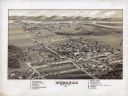
| Date: | 1869 |
|---|---|
| Description: | Birds-eye drawing of Boscobel, Grant County, depicts street names and street layouts, houses, rivers and trees. A reference key at the bottom of the map sh... |
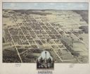
| Date: | 1875 |
|---|---|
| Description: | Bird's-eye map of Lancaster, with inset of Monument for the Soldiers of Grant County. |

| Date: | 1875 |
|---|---|
| Description: | Bird's-eye map of Platteville. |
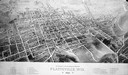
| Date: | 1896 |
|---|---|
| Description: | Bird's-eye map of Platteville with twenty-two locations identified below image. Town square to left of center, behind Main Street. Area bordered by Lancast... |

| Date: | |
|---|---|
| Description: | Composite of sixteen views mainly views of types of boats on the Mississippi River, including steamboats and excursion boats; one view is a bird-eye view o... |

| Date: | |
|---|---|
| Description: | A bird's eye view overlooking the Mississippi River, sand bars, the railroad bridge, surrounding forests and wetlands. |

| Date: | 1908 |
|---|---|
| Description: | Elevated photographic postcard view of town showing homes and businesses. A windmill is in the foreground. The school is on the far edge of town on the lef... |
If you didn't find the material you searched for, our Library Reference Staff can help.
Call our reference desk at 608-264-6535 or email us at: