 Filter: Categories of Wisconsin Historical Images
Filter: County of Grant
Filter: Subject of aerial photographs
Filter: Categories of Wisconsin Historical Images
Filter: County of Grant
Filter: Subject of aerial photographs

| Date: | 1920 |
|---|---|
| Description: | Aerial view of the last covered bridge, which is no longer standing. |
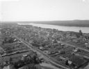
| Date: | 1900 |
|---|---|
| Description: | Aerial view of town. The Mississippi River and far shoreline is in the background. The Furnace Branch creek runs through the town in the foreground. |
| Date: | 10 12 1947 |
|---|---|
| Description: | Aerial view of Cuba City Cannery. |
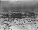
| Date: | 02 17 1949 |
|---|---|
| Description: | One of five aerial views of Platteville and surrounding countryside covered in snow. |
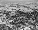
| Date: | 02 17 1949 |
|---|---|
| Description: | One of five aerial views of Platteville and surrounding countryside covered in snow. |
| Date: | 03 28 1949 |
|---|---|
| Description: | Aerial photographs of Boscobel, Wisconsin. |

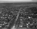
| Date: | 10 24 1946 |
|---|---|
| Description: | Photographic postcard of an aerial view of town. Text below reads: "Aerial View — Boscobel, Wis." |
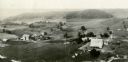
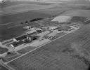
| Date: | 1930 |
|---|---|
| Description: | Aerial view of two farms, with fields and barns in a valley. This image appeared in Joseph Schafer's 1932 book The Wisconsin Lead Region, on a photo... |
If you didn't find the material you searched for, our Library Reference Staff can help.
Call our reference desk at 608-264-6535 or email us at: