Filter: Categories of Wisconsin Historical Images
Filter: County of Grant
Filter: Type of Map or Atlas
Filter: Subject of roads
Filter: Year of 1800-1899
Filter: Categories of Wisconsin Historical Images
Filter: County of Grant
Filter: Type of Map or Atlas
Filter: Subject of roads
Filter: Year of 1800-1899

| Date: | 1869 |
|---|---|
| Description: | Birds-eye drawing of Boscobel, Grant County, depicts street names and street layouts, houses, rivers and trees. A reference key at the bottom of the map sh... |

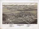
| Date: | 1875 |
|---|---|
| Description: | Bird's-eye map of Platteville. |

| Date: | 1842 |
|---|---|
| Description: | Relief shown by hachures. Shows furnaces, saw mills, houses, roads, grist mills, entries, reservations, and diggings. "Compiled by order of the Board of C... |

| Date: | 1857 |
|---|---|
| Description: | Relief shown by hachures. "Lith. of Ed. Mendel, Chicago." Shows townships and sections, rivers, roads, railroads, houses, flour mills, saw mills, furnaces... |

| Date: | 1850 |
|---|---|
| Description: | This map of Cassville shows plat of the town, roads, landings and public wharfs and the Mississippi River. |
If you didn't find the material you searched for, our Library Reference Staff can help.
Call our reference desk at 608-264-6535 or email us at: