 Filter: Categories of Wisconsin Historical Images
Filter: County of Grant
Filter: Type of Map or Atlas
Filter: Community of Montfort
Filter: Categories of Wisconsin Historical Images
Filter: County of Grant
Filter: Type of Map or Atlas
Filter: Community of Montfort
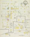
| Date: | 12 1899 |
|---|---|
| Description: | Sanborn map of Montfort, population 800. |

| Date: | 1928 |
|---|---|
| Description: | Shows different types of roads, railroads, schools, churches, farmsteads, cheese factories, mine shafts, old surface workings, streams, old sulphur pits, a... |

| Date: | 1848 |
|---|---|
| Description: | Pen-and-ink on paper. Includes certifications signed by "Geo R. Bluntz, District Survey of Grant Co. W.T." and Ben C. Eastman. |
If you didn't find the material you searched for, our Library Reference Staff can help.
Call our reference desk at 608-264-6535 or email us at: