Filter: Categories of Wisconsin Historical Images
Filter: County of Fond du Lac
Filter: Year of 1800-1899
Filter: Categories of Wisconsin Historical Images
Filter: County of Fond du Lac
Filter: Year of 1800-1899
| Date: | 1872 |
|---|---|
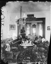
| Description: | View of two rooms possibly in the Martin K. Dahl home. The room in the foreground has a square entrance way and is filled with a piano, three matched chair... |
| Date: | 1874 |
|---|---|
| Description: | Elevated view of a man with a wheelbarrow standing amid vast stacks of cut wood in the yard of a pulp mill. |
| Date: | 1875 |
|---|---|
| Description: | View of the J.S. Morris Carriage and Sleigh Factory, a two-story frame building on Franklin Street in Waupun. Carriages and men in work aprons are in front... |
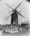
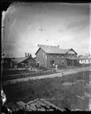
| Date: | 1896 |
|---|---|
| Description: | Flour and grist mill built on Green Lake Prairie and later moved to Alto. It stood about 50 feet tall and 24 feet wide. |

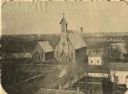
| Date: | 1865 |
|---|---|
| Description: | Elevated view of the Congregational church and surrounding buildings. |
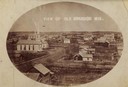
| Date: | 1880 |
|---|---|
| Description: | Elevated view of town, including a church and multiple surrounding buildings. |

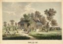
| Date: | 1837 |
|---|---|
| Description: | Fond du Lac Company House, built in 1836 and operated as an inn by Colwert Pier and his wife. Groups of Indians are in the yard outside the inn, and severa... |
| Date: | 1837 |
|---|---|
| Description: | Fond du Lac Company House. Groups of Indians are in the yard outside the inn, and several Indian dwellings are erected next to it. A man on horseback with ... |
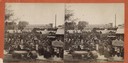
| Date: | 1890 |
|---|---|
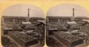
| Description: | Stereograph view of a large crowd of people on a construction site. There is a horse and carriage with the Fond du Lac Machine & Iron Works in the backgrou... |
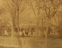
| Date: | 1880 |
|---|---|
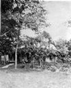
| Description: | Simmons residence, with people sitting on the porch and standing near the front entrance. |

| Date: | 1848 |
|---|---|
| Description: | Foldout map of a sketch of the town grid of Calumet. |

| Date: | 1857 |
|---|---|
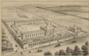
| Description: | A quarter section of a map of the city of Fond du Lac. This section features an illustration of Amory Hall and the Exchange Bank of Darling & Co. |

| Date: | 1857 |
|---|---|
| Description: | A quarter section of a map of the City of Fond du Lac featuring the Empire Branch Plank Road. |

| Date: | 1857 |
|---|---|
| Description: | Quarter section of a map of the city of Fond du Lac featuring the Waupun Plank Road. |

| Date: | 1857 |
|---|---|
| Description: | Quarter section of a map of the city of Fond du Lac featuring an illustration of the Lewis House. |
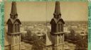
| Date: | 1875 |
|---|---|
| Description: | Elevated stereograph view of the business district, with the spire of the Congregational Church in the foreground. |
| Date: | 1864 |
|---|---|
| Description: | Elevated view of St. Peter's Episcopal Church. |
If you didn't find the material you searched for, our Library Reference Staff can help.
Call our reference desk at 608-264-6535 or email us at: