 Filter: Categories of Wisconsin Historical Images
Filter: County of Dunn
Filter: Year of 1800-1899
Filter: Year of 1870-1879
Filter: Categories of Wisconsin Historical Images
Filter: County of Dunn
Filter: Year of 1800-1899
Filter: Year of 1870-1879

| Date: | 1875 |
|---|---|
| Description: | Bird's-eye map of Menomonie, with an inset of the County Court House. Spelled Menomonee on map. |
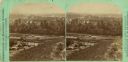
| Date: | 1875 |
|---|---|
| Description: | Stereograph elevated view of a river and homes of Menomonie. |

| Date: | 1875 |
|---|---|
| Description: | This plat map shows local streets, buildings, numbered blocks and lots, part of the Red Cedar River, and land ownership by name. Also included is a busines... |

| Date: | 1877 |
|---|---|
| Description: | This map is a photstat copy of the original and shows landownership, townships and sections, wagon roads, railroads, school houses, churches, cemeteries, m... |
If you didn't find the material you searched for, our Library Reference Staff can help.
Call our reference desk at 608-264-6535 or email us at: