 Filter: Categories of Wisconsin Historical Images
Filter: County of Dunn
Filter: Year of 1800-1899
Filter: Categories of Wisconsin Historical Images
Filter: County of Dunn
Filter: Year of 1800-1899
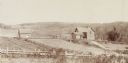
| Date: | 1898 |
|---|---|
| Description: | View from field of farm with a wide view of the surrounding landscape. |

| Date: | 1859 |
|---|---|
| Description: | This plat map is pen on paper and shows numbered blocks and lots, local streets, and section lines. Also included is text on survey certifications. |

| Date: | 1859 |
|---|---|
| Description: | This plat map is pen on paper and shows numbered blocks and lots, local streets, and section lines. Also included is text on survey certifications. The top... |

| Date: | 1875 |
|---|---|
| Description: | This plat map shows local streets, buildings, numbered blocks and lots, part of the Red Cedar River, and land ownership by name. Also included is a busines... |

| Date: | 1896 |
|---|---|
| Description: | This map shows plat of town, local streets, numbered blocks and lots, mill pond, mills, part of the Red Cedar River, and land and property ownership by nam... |

| Date: | 1877 |
|---|---|
| Description: | This map is a photstat copy of the original and shows landownership, townships and sections, wagon roads, railroads, school houses, churches, cemeteries, m... |
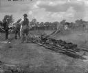
| Date: | 07 04 1899 |
|---|---|
| Description: | Fourth of July Barbecue in Menomonie arranged by the citizens and inspected by J.H. Stout. Thirteen quarters of beef were roasted and 8000 pints of soup se... |
If you didn't find the material you searched for, our Library Reference Staff can help.
Call our reference desk at 608-264-6535 or email us at: