 Filter: Categories of Wisconsin Historical Images
Filter: County of Dunn
Filter: Year of 1800-1899
Filter: Community of Menomonie
Filter: Categories of Wisconsin Historical Images
Filter: County of Dunn
Filter: Year of 1800-1899
Filter: Community of Menomonie

| Date: | 1875 |
|---|---|
| Description: | Bird's-eye map of Menomonie, with an inset of the County Court House. Spelled Menomonee on map. |
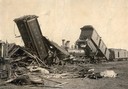
| Date: | 09 09 1881 |
|---|---|
| Description: | Wreck of the Chicago, St. Paul, Minneapolis and Omaha railroad line on the Teegarten farm near Menomonie. Dead cows are in the foreground. |
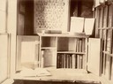
| Date: | 1897 |
|---|---|
| Description: | A traveling library station in the Saudvig home. |

| Date: | 1890 |
|---|---|
| Description: | Stereograph elevated view of a residential neighborhood in Menomonie. |
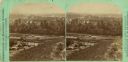
| Date: | 1875 |
|---|---|
| Description: | Stereograph elevated view of a river and homes of Menomonie. |
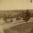
| Date: | 1880 |
|---|---|
| Description: | The view of Red Cedar River from Meadow Hill. |

| Date: | 1885 |
|---|---|
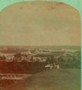
| Description: | Stereograph view of Menomonie. A group of people are sitting on a hill in the foreground overlooking the town. |
| Date: | 1895 |
|---|---|
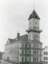
| Description: | The Industrial Building at Stout State College. The building was built in 1893 and was destroyed by fire in 1897. |
| Date: | 1890 |
|---|---|
| Description: | The Stout Manual Training School, later a part of Stout State College. |

| Date: | 1858 |
|---|---|
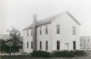
| Description: | Pencil sketch of the Jacob Miller home. |

| Date: | 1880 |
|---|---|
| Description: | Elevated view of Red Cedar (or Menomonie) River and the Knapp, Stout & Co., mills from the top of present day Meadow Hill Dr. looking Southeast. |
| Date: | 1899 |
|---|---|
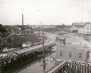
| Description: | Elevated view looking north towards Menomonie, the Knapp, Stout and Company lumber mills. |

| Date: | 1887 |
|---|---|
| Description: | Mill workers in the yard at Ramsay & Jones Mill. |

| Date: | 1887 |
|---|---|
| Description: | The bay shore of Menominee filled with driftwood. |
| Date: | 1885 |
|---|---|
| Description: | Stereograph view of Menomonie. A group of people sit on a hill in the foreground overlooking the town. |

| Date: | 1895 |
|---|---|
| Description: | A view of purebred Shropshire ewes grouped together in a fenced-in pasture on the stock farm of Andrew Tainter. |

| Date: | 1859 |
|---|---|
| Description: | This plat map is pen on paper and shows numbered blocks and lots, local streets, and section lines. Also included is text on survey certifications. |

| Date: | 1859 |
|---|---|
| Description: | This plat map is pen on paper and shows numbered blocks and lots, local streets, and section lines. Also included is text on survey certifications. The top... |

| Date: | 1875 |
|---|---|
| Description: | This plat map shows local streets, buildings, numbered blocks and lots, part of the Red Cedar River, and land ownership by name. Also included is a busines... |
If you didn't find the material you searched for, our Library Reference Staff can help.
Call our reference desk at 608-264-6535 or email us at:
