 Filter: Categories of Wisconsin Historical Images
Filter: County of Dunn
Filter: Subject of human settlements
Filter: Categories of Wisconsin Historical Images
Filter: County of Dunn
Filter: Subject of human settlements
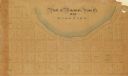
| Date: | 1880 |
|---|---|
| Description: | This plat of Vanceburg Cemetery, Town of Sheridan, Dunn County, Wisconsin, likely dates from the 1880s and "is intended for the correction of names of peop... |
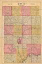
| Date: | |
|---|---|
| Description: | Shows township borders and includes township and range numbers as well as property owner’s names. |
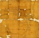
| Date: | 1860 |
|---|---|
| Description: | Pencil and ink on paper. "Showing the government meander line on the left bank of Rock River and the actual course of Rock River together with the several ... |

| Date: | 1855 |
|---|---|
| Description: | Map reads: "Knapp, Stout & Co., William Carson, Henry Eaton, Amos Collum, William Wilson & C.S. Bundy Proprietors."Streets running horizontally begin at th... |

| Date: | 1890 |
|---|---|
| Description: | Shows plat of town, local streets, steam boat landings, and Chippewa River. Public square and Muskoo Island hand-colored. Map reads: "Full Lots are 125x66 ... |
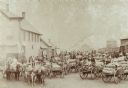
| Date: | 1898 |
|---|---|
| Description: | Farmers with their loads waiting to ship on train number 40 at Colfax, Wisconsin. "An everyday occurrence at 3:50 pm during September and October." |
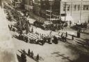
| Date: | 11 11 1918 |
|---|---|
| Description: | Elevated view from building of informal Armistice Day street parade at an intersection of the downtown area. They are celebrating the conclusion of the fir... |
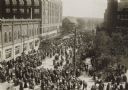
| Date: | 11 11 1918 |
|---|---|
| Description: | Elevated view from building of informal Armistice Day street parade at an intersection of the downtown area. They are celebrating the conclusion of the fir... |
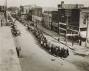
| Date: | 05 21 1919 |
|---|---|
| Description: | Elevated view of street entertainment, with crowds, dancing and band concert to welcome home Wisconsin National Guard, 3d Regiment, Company H, after servic... |

| Date: | 1960 |
|---|---|
| Description: | This map shows lot and block numbers, additions, and rural acreages and includes an index of rail roads, industrial plants, Dunn County and Menominee owned... |
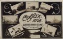
| Date: | 11 16 1908 |
|---|---|
| Description: | Photographic COLLAGE postcard of scenes of Colfax. In the center oval is the text, "Colfax, Wis. Looks Good To Me," however the "Looks Good To Me" is cross... |
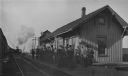
| Date: | 1900 |
|---|---|
| Description: | View across railroad tracks towards passengers, a large group of men and one young girl, waiting on the platform at the train station for the train to arri... |
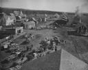
| Date: | 08 1902 |
|---|---|
| Description: | Elevated view of the railroad depot taken from the wooden shake roof of a building. On the right are railroad tracks, depot buildings, grain storage and a ... |

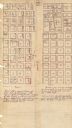
| Date: | 1859 |
|---|---|
| Description: | This plat map is pen on paper and shows numbered blocks and lots, local streets, and section lines. Also included is text on survey certifications. |

| Date: | 1859 |
|---|---|
| Description: | This plat map is pen on paper and shows numbered blocks and lots, local streets, and section lines. Also included is text on survey certifications. The top... |
| Date: | |
|---|---|
| Description: | This plat map is pen, pencil, and watercolor on paper and shows numbered blocks and lots, local streets, section lines, the public square, Mill pond, and l... |

| Date: | 1875 |
|---|---|
| Description: | This plat map shows local streets, buildings, numbered blocks and lots, part of the Red Cedar River, and land ownership by name. Also included is a busines... |

| Date: | 1896 |
|---|---|
| Description: | This map shows plat of town, local streets, numbered blocks and lots, mill pond, mills, part of the Red Cedar River, and land and property ownership by nam... |

| Date: | 1911 |
|---|---|
| Description: | This map shows plat of town, local streets, numbered lots, blocks, and wards, roads, Lake Menomin, Wilson Creek, Red Cedar River, and land ownership by nam... |

| Date: | 1877 |
|---|---|
| Description: | This map is a photstat copy of the original and shows landownership, townships and sections, wagon roads, railroads, school houses, churches, cemeteries, m... |
If you didn't find the material you searched for, our Library Reference Staff can help.
Call our reference desk at 608-264-6535 or email us at: