 Filter: Categories of Wisconsin Historical Images
Filter: County of Dunn
Filter: Subject of cemeteries
Filter: Categories of Wisconsin Historical Images
Filter: County of Dunn
Filter: Subject of cemeteries
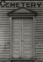
| Date: | 1936 |
|---|---|
| Description: | A view of the Paynesville Cemetery Chapel, entrance detail. |
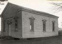
| Date: | 1936 |
|---|---|
| Description: | A view of the Paynesville Cemetery Chapel (south elevation). |
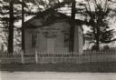
| Date: | 1936 |
|---|---|
| Description: | A view of the Paynesville Cemetery Chapel from the southeast. |

| Date: | 1970 |
|---|---|
| Description: | This pictorial map of Dunn County, Wisconsin, from the 1970s depicts historical events that occurred in the county. It shows cemeteries, churches, schools,... |
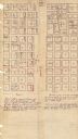
| Date: | 1880 |
|---|---|
| Description: | This plat of Vanceburg Cemetery, Town of Sheridan, Dunn County, Wisconsin, likely dates from the 1880s and "is intended for the correction of names of peop... |

| Date: | 1877 |
|---|---|
| Description: | This map is a photstat copy of the original and shows landownership, townships and sections, wagon roads, railroads, school houses, churches, cemeteries, m... |

| Date: | 1907 |
|---|---|
| Description: | This blueprint map shows a proposed plan for pleasure roads and reservation system. It also shows schools, cemeteries, old river channel, proposed bridge, ... |
If you didn't find the material you searched for, our Library Reference Staff can help.
Call our reference desk at 608-264-6535 or email us at: