 Filter: Categories of Wisconsin Historical Images
Filter: County of Dunn
Filter: Type of Map or Atlas
Filter: Year of 1900-1999
Filter: Subject of rivers
Filter: Categories of Wisconsin Historical Images
Filter: County of Dunn
Filter: Type of Map or Atlas
Filter: Year of 1900-1999
Filter: Subject of rivers
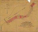
| Date: | 1950 |
|---|---|
| Description: | This map shows the plat of the village of Lakehurst, on the Red Cedar River in the Town of Tainter, Dunn County, Wisconsin. |
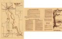
| Date: | 1974 |
|---|---|
| Description: | This 1974 map shows historical sites related to Caddie Woodlawn, a book by Carol Ryrie Brink, in the Town of Dunn, Dunn County, Wisconsin. Some landmarks a... |

| Date: | 1911 |
|---|---|
| Description: | This map shows plat of town, local streets, numbered lots, blocks, and wards, roads, Lake Menomin, Wilson Creek, Red Cedar River, and land ownership by nam... |

| Date: | 1907 |
|---|---|
| Description: | This blueprint map shows a proposed plan for pleasure roads and reservation system. It also shows schools, cemeteries, old river channel, proposed bridge, ... |
If you didn't find the material you searched for, our Library Reference Staff can help.
Call our reference desk at 608-264-6535 or email us at:
