Filter: Categories of Wisconsin Historical Images
Filter: County of Douglas
Filter: Year of 1800-1899
Filter: Subject of superior, lake
Filter: Categories of Wisconsin Historical Images
Filter: County of Douglas
Filter: Year of 1800-1899
Filter: Subject of superior, lake
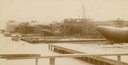
| Date: | 04 1893 |
|---|---|
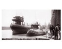
| Description: | Captain Abe McDougall's whaleback boat, docked at the American Steel Barge Company. |
| Date: | 04 1893 |
|---|---|
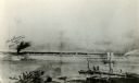
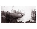
| Description: | Launching Captain Abe McDougall's whaleback boat, "Christopher Columbus", from the American Steel Barge Company dock. |
| Date: | 09 19 1892 |
|---|---|
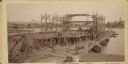
| Description: | Captain Alexander McDougall's whaleback passenger steamer "Christopher Columbus" under construction in the shipyard of the American Steel Barge Company in ... |
| Date: | 1892 |
|---|---|
| Description: | Text at bottom reads: Ship Yards — McDougall Whaleback. West Superior, Wis." Whaleback steamer in the shipyards of the American Steel Barge Company. |
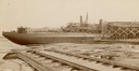
| Date: | 1892 |
|---|---|
| Description: | Text at bottom reads: Ship Yards — McDougall Whaleback. West Superior, Wis." Captain Alex McDougall's whaleback steamer in the shipyard of the American Ste... |

| Date: | 1883 |
|---|---|
| Description: | Bird's-eye map of Superior, county seat of Douglas County, on the shores of Lake Superior, with insets of points of interest. |

| Date: | 1887 |
|---|---|
| Description: | Bird's-eye view of Superior, on Lake Superior. |

| Date: | 1890 |
|---|---|
| Description: | Bird's-eye map of West Superior and Superior, with insets of Wright Farm and First Building in Superior. |

| Date: | 01 04 1862 |
|---|---|
| Description: | Engraving of the city of Superior and Lake Superior, also depicting railroad piers, Minnesota Point, and the steamboat "Star". The engraving appears on a l... |

| Date: | 1885 |
|---|---|
| Description: | Illustrated view of Superior, as well as Omaha, Kansas City, St. Paul, and Winnipeg. Caption reads: "Superior - The Last Possible Great Marine City in the ... |

| Date: | 1891 |
|---|---|
| Description: | Photograph of a painting by May Conniff Frost showing the tugboat Record of the Inman Line pulling a lake schooner through rough waters into Superio... |

| Date: | 1896 |
|---|---|
| Description: | This 1896 map of Douglas County, Wisconsin, shows the township and range grid, the towns of Superior, Brule, Gordon, and Nebagamain, sections, cities and v... |

| Date: | 1890 |
|---|---|
| Description: | This map of Superior shows labeled streets, railroads, docks, city wards, and the state line. Relief is shown by hachures. Below the title reads: "Bedford ... |

| Date: | 1890 |
|---|---|
| Description: | This map of Superior shows city wards, bays, docks, some businesses and points of interest. Relief is shown by hachures. The back of the map features a typ... |

| Date: | 1898 |
|---|---|
| Description: | This map of Superior shows city wards, bays, docks, and some businesses and points of interest. Relief is shown by hachures. The map probably came from a C... |

| Date: | 1898 |
|---|---|
| Description: | This map of Duluth and Superior show lands that "will be for sale soon" in portions of Douglas County, Wisconsin and Saint Louis County, Minnesota. The map... |

| Date: | 1860 |
|---|---|
| Description: | This map of Superior is oriented with north to the upper left. Relief is shown by hachures and water depths are shown by soundings. Lake Superior and bays ... |

| Date: | 1863 |
|---|---|
| Description: | This map of Superior shows Montgomery's Addition. An inset map shows the south west end of Lake Superior where Montgomery's Addition is located. The map re... |

| Date: | 1891 |
|---|---|
| Description: | This colorful map shows additions, railroads, docks, streets, established dock lines, marshes, and proposed belt line railroad. The map covers west and sou... |
If you didn't find the material you searched for, our Library Reference Staff can help.
Call our reference desk at 608-264-6535 or email us at: