Filter: Categories of Wisconsin Historical Images
Filter: County of Douglas
Filter: Subject of land use
Filter: Categories of Wisconsin Historical Images
Filter: County of Douglas
Filter: Subject of land use

| Date: | 1890 |
|---|---|
| Description: | Bird's-eye map of West Superior and Superior, with insets of Wright Farm and First Building in Superior. |

| Date: | 1930 |
|---|---|
| Description: | View of bridge and Brule River monument. Placed where the Brule River is crossed by the Memorial Highway from Superior to Brule and Ashland (Highway 2). |
| Date: | 1930 |
|---|---|
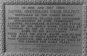
| Description: | Inscription of Brule River monument. Placed where the Brule River is crossed by the Memorial Highway from Superior to Brule and Ashland (Highway 2). |
| Date: | |
|---|---|
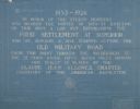
| Description: | Blueprint of the Military Road marker design, which honors the pioneers who established the first settlement in Superior. |
| Date: | 1930 |
|---|---|
| Description: | View of the Davidson Feed Mill near the Amnicon River. |
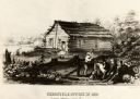
| Date: | 1855 |
|---|---|
| Description: | Chronicle newspaper office, the first building on the townsite of Superior, built in 1853 by William C. Howenstine, John T. Morgan, and August Zachau. |
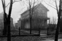
| Date: | 1930 |
|---|---|
| Description: | Exterior view of the Ashton home, built in about 1853 or 1854. |
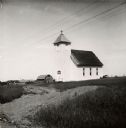
| Date: | 07 1947 |
|---|---|
| Description: | Exterior view of Suomi Synod Church. A farm is visible in the distance. |
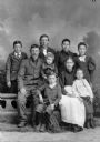
| Date: | |
|---|---|
| Description: | A large group consisting of five males and four females pose for a studio portrait in front of a painted backdrop around a studio prop of a stone wall. The... |
| Date: | 1890 |
|---|---|
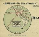
| Description: | Letterhead for Moulton, Moran & Co. The logo shows North America and depicts Superior as the center of a hub with spokes going to Russia, to China and Japa... |
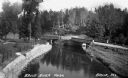
| Date: | 1935 |
|---|---|
| Description: | Elevated view of the Brule River in northern Wisconsin, flowing between a road and landscaped stone wall under a bridge and pedestrian walkway. |
| Date: | 11 1952 |
|---|---|
| Description: | John Lavine (left), Nancy Jane Nelson, Virginia Rafshol, and Gary Berger indicate their support for the presidential candidacy of Dwight D. Eisenhower. As ... |
| Date: | 09 07 1895 |
|---|---|
| Description: | A garden of red currant bushes, owned by Jas. S. Ritchie, are featured on his fruit farm. |

| Date: | 1943 |
|---|---|
| Description: | Shows portage trail, monuments, and hydrography in part of Solon Springs township, Douglas County, Wis. "All sections are in T45N, R11W." |
| Date: | 1933 |
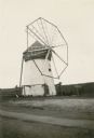
|---|---|
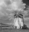
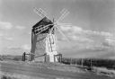
| Description: | A windmill with eight vanes stands along an unpaved road. The mill was built by Jacob Davidson in 1904 to grind flour and livestock feed. Davidson hand-hew... |

| Date: | 1934 |
|---|---|
| Description: | This map shows industrial points of interest in Superior. The top of the map reads: "Superior, Douglas County, Wisconsin, as this Industrial Tour map indic... |
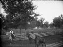
| Date: | |
|---|---|
| Description: | Two women posing sidesaddle on two horses on a dirt path with a wooden board fence behind them. In the foreground is a colt. In the background are a field ... |

| Date: | 1972 |
|---|---|
| Description: | Before or after a Minnesota vs. Wisconsin Democrats softball game. Congressman David Obey holds up a concept rendering the future Richard I. Bong Memorial ... |

| Date: | 1861 |
|---|---|
| Description: | This map shows lot and block numbers, piers, streets, monuments, and township section corners. Included is a note on the width of avenues, piers, slips, al... |
If you didn't find the material you searched for, our Library Reference Staff can help.
Call our reference desk at 608-264-6535 or email us at: