 Filter: Categories of Wisconsin Historical Images
Filter: County of Douglas
Filter: Subject of islands
Filter: Categories of Wisconsin Historical Images
Filter: County of Douglas
Filter: Subject of islands
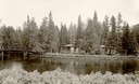
| Date: | 1930 |
|---|---|
| Description: | Cedar Island on Brule River, a nationally known speckle trout stream. The island has native towering white pine and bubbling clear springs. These are some ... |

| Date: | 1916 |
|---|---|
| Description: | This map is mounted on cloth and shows lots and roads. An inset map is included that shows towns, lakes, rivers, and railroads within portions of the Dakot... |

| Date: | 1990 |
|---|---|
| Description: | This map shows the Minnesota Point, Wisconsin Point, Hog Island, Baker's Island, Connors Point, Blatnik Bridge, Superior Bay, Allouez Bay, the Nemadji Rive... |
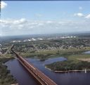
| Date: | 08 1971 |
|---|---|
| Description: | Aerial view of an ore dock next to Hog Island. The town is in the distance. In the far background are the white storage buildings of the oil refinery. |

| Date: | 1940 |
|---|---|
| Description: | Text on front reads: "Billings Park, Superior, Wis." A city park on the St. Louis River, a freshwater estuary. Small islands with several bridges are surro... |
If you didn't find the material you searched for, our Library Reference Staff can help.
Call our reference desk at 608-264-6535 or email us at: