 Filter: Categories of Wisconsin Historical Images
Filter: County of Douglas
Filter: Subject of industries
Filter: Categories of Wisconsin Historical Images
Filter: County of Douglas
Filter: Subject of industries
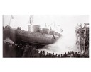
| Date: | 04 1893 |
|---|---|
| Description: | Launching Captain Abe McDougall's whaleback boat, "Christopher Columbus", from the American Steel Barge Company dock. |
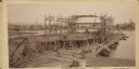
| Date: | 09 19 1892 |
|---|---|
| Description: | Captain Alexander McDougall's whaleback passenger steamer "Christopher Columbus" under construction in the shipyard of the American Steel Barge Company in ... |
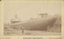
| Date: | 1892 |
|---|---|
| Description: | Text at bottom reads: "McDougal [sic] Whaleback. [manufactured at] West Superior, Wis." The steamer is under construction in the American Steel Barge Compa... |
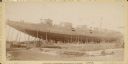
| Date: | 1892 |
|---|---|
| Description: | Whaleback steamer under construction in the American Steel Barge Company shipyard in Superior, Wisconsin. Text at bottom of card reads: "McDougall Passenge... |
| Date: | |
|---|---|
| Description: | Colorized image of the frame of a large boat being built at the shipyards in Superior. |

| Date: | 1913 |
|---|---|
| Description: | Bird's-eye map of Superior. "The New Steel Center." |

| Date: | 1889 |
|---|---|
| Description: | This 1889 map of Douglas County, Wisconsin, shows the township and range grid, towns, sections, cities and villages, roads, existing and proposed railroads... |

| Date: | 1892 |
|---|---|
| Description: | This 1892 map of Douglas County, Wisconsin, shows the township and range grid, towns, sections, cities and villages, roads, railroads, trails, lakes and st... |

| Date: | 1899 |
|---|---|
| Description: | This 1899 map of Douglas County, Wisconsin, shows the township and range grid, towns, sections, cities, villages and railroad stations, mines, roads, railr... |

| Date: | 1934 |
|---|---|
| Description: | This map shows industrial points of interest in Superior. The top of the map reads: "Superior, Douglas County, Wisconsin, as this Industrial Tour map indic... |
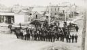
| Date: | 1889 |
|---|---|
| Description: | Elevated view of group gathered and posed on a new street. Behind the group is a large pile of lumber, wooden sidewalks, and what appear to be newly-constr... |
| Date: | 1960 |
|---|---|
| Description: | Several men are working with logs and equipment in Brule River State Forest. |

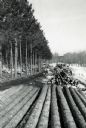
| Date: | 1960 |
|---|---|
| Description: | Several piles of logs along a logging road waiting for truck pick up. |

| Date: | 1901 |
|---|---|
| Description: | This map shows streets, industrial buildings, a portion of Lake Superior and other lakes, bays, and rivers in portions of Duluth and Superior. Relief is sh... |

| Date: | |
|---|---|
| Description: | View over parked cars towards the Superior Refinery, which did business as Murphy Oil Corporation at another time. The oil refinery was located at Stinson ... |

| Date: | |
|---|---|
| Description: | View across field towards the Superior Refinery, which operated under the name Murphy Oil Corporation at another time. |

| Date: | 1892 |
|---|---|
| Description: | A Sanborn map of St. Louis, which is six miles southwest of South Superior. |
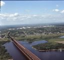
| Date: | 08 1971 |
|---|---|
| Description: | Aerial view of an ore dock next to Hog Island. The town is in the distance. In the far background are the white storage buildings of the oil refinery. |
| Date: | |
|---|---|
| Description: | View across water towards the cargo ship "Henry LaLiberte" sitting in a loading dock under a cargo crane. |
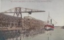
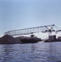
| Date: | 1904 |
|---|---|
| Description: | Text on front reads: "Ore Docks, Superior, Wis." Elevated view of an ore carrying ship that is within the ore docks on Lake Superior. |
If you didn't find the material you searched for, our Library Reference Staff can help.
Call our reference desk at 608-264-6535 or email us at: