 Filter: Categories of Wisconsin Historical Images
Filter: County of Douglas
Filter: Subject of human settlements
Filter: Categories of Wisconsin Historical Images
Filter: County of Douglas
Filter: Subject of human settlements
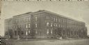
| Date: | 1890 |
|---|---|
| Description: | Exterior view from across street of Roosevelt Terrace apartments. |
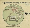
| Date: | 1890 |
|---|---|
| Description: | Letterhead for Moulton, Moran & Co. The logo shows North America and depicts Superior as the center of a hub with spokes going to Russia, to China and Japa... |
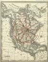
| Date: | 1890 |
|---|---|
| Description: | Rand, McNally map of North America enhanced to show Superior as the center of a wheel. The image was used on the back of stationery from City Improvement C... |
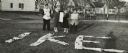
| Date: | 11 1952 |
|---|---|
| Description: | John Lavine (left), Nancy Jane Nelson, Virginia Rafshol, and Gary Berger indicate their support for the presidential candidacy of Dwight D. Eisenhower. As ... |
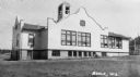
| Date: | 1937 |
|---|---|
| Description: | Large white building with facade details and bell tower. |

| Date: | |
|---|---|
| Description: | Letterhead of the City of Superior, Wisconsin, with a three-quarter view of City Hall, printed in blue-green ink, with additional text in brown ink, by Typ... |

| Date: | 1889 |
|---|---|
| Description: | This 1889 map of Douglas County, Wisconsin, shows the township and range grid, towns, sections, cities and villages, roads, existing and proposed railroads... |

| Date: | 1892 |
|---|---|
| Description: | This 1892 map of Douglas County, Wisconsin, shows the township and range grid, towns, sections, cities and villages, roads, railroads, trails, lakes and st... |

| Date: | 1899 |
|---|---|
| Description: | This 1899 map of Douglas County, Wisconsin, shows the township and range grid, towns, sections, cities, villages and railroad stations, mines, roads, railr... |

| Date: | 1911 |
|---|---|
| Description: | This map, taken from the 1911 Map of Wisconsin showing geology and roads by Hotchkiss and Thwaites, shows the northwest portion of Douglas County, Wisconsi... |

| Date: | 1914 |
|---|---|
| Description: | This 1914 map of Douglas County, Wisconsin, shows the township and range grid, towns, sections, cities and villages, roads, railroads, Indian trails, schoo... |

| Date: | 1943 |
|---|---|
| Description: | Shows portage trail, monuments, and hydrography in part of Solon Springs township, Douglas County, Wis. "All sections are in T45N, R11W." |

| Date: | 1953 |
|---|---|
| Description: | This is a detailed map of Douglas County, Wisconsin, showing townships and township borders, numbered wards, roadways, and bodies of water. There are annot... |

| Date: | 1890 |
|---|---|
| Description: | This map of Douglas County, Wisconsin, published around the beginning of the 20th century shows the copper bearing formations in the county on a map that a... |

| Date: | 1800 |
|---|---|
| Description: | This pen and ink drawing with watercolor shows the course of the Black River from Rock Creek, near Greenwood in Clark County, Wisconsin, to its confluence ... |

| Date: | 1896 |
|---|---|
| Description: | This 1896 map of Douglas County, Wisconsin, shows the township and range grid, the towns of Superior, Brule, Gordon, and Nebagamain, sections, cities and v... |

| Date: | 1930 |
|---|---|
| Description: | Shows county system of roads which are surfaced, well graded, common, or unimproved, town roads, state trunk highways, town and village boundaries, schools... |

| Date: | 1929 |
|---|---|
| Description: | "Compliments of the Douglas County Highway Department"--Top margin. Shows state-trunk highways, county highways, town roads, trails, boundaries, and concr... |

| Date: | 1953 |
|---|---|
| Description: | "Compliments of the Douglas County Highway Department"--Top margin. Shows federal highways, state trunk highways, county highways, town roads, unimproved ... |

| Date: | 1930 |
|---|---|
| Description: | Shows county system of roads which are surfaced, well graded, common, or unimproved, town roads, state trunk highways, town and village boundaries, schools... |
If you didn't find the material you searched for, our Library Reference Staff can help.
Call our reference desk at 608-264-6535 or email us at: