Filter: Categories of Wisconsin Historical Images
Filter: County of Douglas
Filter: Subject of human settlements
Filter: Year of 1900-1999
Filter: Year of 1930-1939
Filter: Categories of Wisconsin Historical Images
Filter: County of Douglas
Filter: Subject of human settlements
Filter: Year of 1900-1999
Filter: Year of 1930-1939
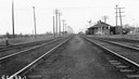
| Date: | 09 10 1939 |
|---|---|
| Description: | View down railroad tracks towards the Central Avenue depot and the railroad crossing. |

| Date: | 1930 |
|---|---|
| Description: | View of bridge and Brule River monument. Placed where the Brule River is crossed by the Memorial Highway from Superior to Brule and Ashland (Highway 2). |
| Date: | 1937 |
|---|---|
| Description: | Exterior view across street toward the Courthouse and Post Office. Caption reads: "U.S. Courthouse and Post Office, Superior, Wis." |
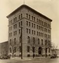
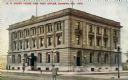
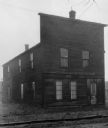
| Date: | 1933 |
|---|---|
| Description: | View of a Vincent Roy storage building, with a man standing to the right of the structure. |
| Date: | 1930 |
|---|---|
| Description: | Exterior view of the Roy trading post, built in about 1857. |
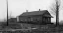
| Date: | 1930 |
|---|---|
| Description: | View of a house built around 1855 which served as a hardware store and a home. |
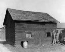
| Date: | 1930 |
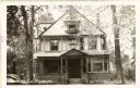
|---|---|
| Description: | Exterior view of a house built in about 1900. |
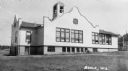
| Date: | 1930 |
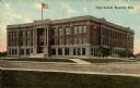
|---|---|
| Description: | Exterior view across street towards a high school. Caption reads: "High School, Superior, Wis." |
| Date: | 1939 |
|---|---|
| Description: | Exterior view of the Douglas County Museum, also known as the A.A. Roth Memorial. The museum was housed here from 1939 to 1963. |
| Date: | 1939 |
|---|---|
| Description: | Exterior view of the Douglas County Historical Society Museum, also known as the A.A. Roth Memorial. The museum was located here from 1939 until 1963. |
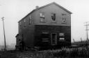
| Date: | 1930 |
|---|---|
| Description: | View of the Davidson Feed Mill near the Amnicon River. |

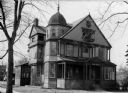
| Date: | 1930 |
|---|---|
| Description: | Exterior view of the Bradshaw home, erected in about 1927 by Peter E. and John W. Bradshaw as a general store. |
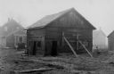
| Date: | 1930 |
|---|---|
| Description: | View of a barn, built between about 1875 and 1876. Buildings are in the background. |
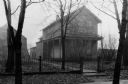
| Date: | 1930 |
|---|---|
| Description: | Exterior view of the Ashton home, built in about 1853 or 1854. |
| Date: | 1937 |
|---|---|
| Description: | Large white building with facade details and bell tower. |

| Date: | 1930 |
|---|---|
| Description: | Shows county system of roads which are surfaced, well graded, common, or unimproved, town roads, state trunk highways, town and village boundaries, schools... |

| Date: | 1930 |
|---|---|
| Description: | Shows county system of roads which are surfaced, well graded, common, or unimproved, town roads, state trunk highways, town and village boundaries, schools... |

| Date: | 1934 |
|---|---|
| Description: | This map shows industrial points of interest in Superior. The top of the map reads: "Superior, Douglas County, Wisconsin, as this Industrial Tour map indic... |
If you didn't find the material you searched for, our Library Reference Staff can help.
Call our reference desk at 608-264-6535 or email us at: