 Filter: Categories of Wisconsin Historical Images
Filter: County of Douglas
Filter: Subject of human settlements
Filter: Year of 1900-1999
Filter: Year of 1910-1919
Filter: Categories of Wisconsin Historical Images
Filter: County of Douglas
Filter: Subject of human settlements
Filter: Year of 1900-1999
Filter: Year of 1910-1919

| Date: | 1913 |
|---|---|
| Description: | Bird's-eye map of Superior. "The New Steel Center." |

| Date: | 1915 |
|---|---|
| Description: | Bird's-eye view of Superior, Wisconsin, and Duluth, Minnesota on opposite shore of Lake Superior. |

| Date: | 1913 |
|---|---|
| Description: | Aerial bridge and harbor, with a large boat passing underneath. A lamppost and a beacon are along the walkway towards the bridge on the left. Caption reads... |
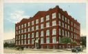
| Date: | 1915 |
|---|---|
| Description: | Exterior view of the Young Men's Christian Association building on a street corner. Caption reads: "Y. M. C. A. Superior, Wis." |
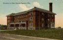
| Date: | 1910 |
|---|---|
| Description: | View from road toward the dormitory. Caption reads: "Dormitory at State Normal, Superior, Wis." |
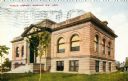
| Date: | 1918 |
|---|---|
| Description: | View towards the front and right side of the library. Caption reads: "Public Library Superior, Wis." |
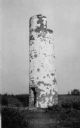
| Date: | 1910 |
|---|---|
| Description: | View of the remnants of the Minnesota Point Lighthouse. Faint caption at bottom reads: "Lighthouse". |

| Date: | 1915 |
|---|---|
| Description: | Elevated view of the harbor. Caption reads: "The Harbor, Superior, Wis." |

| Date: | 1910 |
|---|---|
| Description: | Caption reads: "The Great Northern. One of the largest Elevators in the World, Superior, Wis." |
| Date: | 1915 |
|---|---|
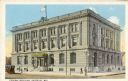
| Description: | Exterior view across street towards the Federal Building. Caption reads: "Federal Building, Superior, Wis." |
| Date: | 1915 |
|---|---|
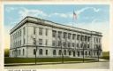
| Description: | Exterior view of the Douglas County Courthouse. Caption reads: "Court House, Superior, Wis." |
| Date: | 1919 |
|---|---|
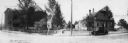
| Description: | Panoramic view of county buildings located at West 5th and Newton Avenues. |
| Date: | 1915 |
|---|---|
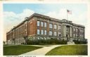
| Description: | Exterior view of Central High School. Caption reads: "Central High School, Superior, Wis." |
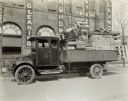
| Date: | 1919 |
|---|---|
| Description: | A man sits in an International model "G" truck that has wood furniture and crates filling the bed. The building behind has signs advertising for a laundry. |

| Date: | 1911 |
|---|---|
| Description: | This map, taken from the 1911 Map of Wisconsin showing geology and roads by Hotchkiss and Thwaites, shows the northwest portion of Douglas County, Wisconsi... |

| Date: | 1914 |
|---|---|
| Description: | This 1914 map of Douglas County, Wisconsin, shows the township and range grid, towns, sections, cities and villages, roads, railroads, Indian trails, schoo... |

| Date: | 1911 |
|---|---|
| Description: | This map of Duluth and Superior shows street car routes, railroads, ferries, some points of interest, and lighthouses. The bottom left of the map reads: "C... |

| Date: | 1917 |
|---|---|
| Description: | This map shows streets, land owners, local businesses, the St. Louis River, and bridges. The maps reads: "Incorporated 1917." The back of the map includes ... |

| Date: | 1916 |
|---|---|
| Description: | This map is mounted on cloth and shows lots and roads. An inset map is included that shows towns, lakes, rivers, and railroads within portions of the Dakot... |
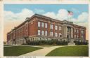
| Date: | 1915 |
|---|---|
| Description: | Text on front reads: "Central High School, Superior, Wis." The school was built in 1909 of brick in the Neoclassical style. In 1928, President Coolidge use... |
If you didn't find the material you searched for, our Library Reference Staff can help.
Call our reference desk at 608-264-6535 or email us at: