Filter: Categories of Wisconsin Historical Images
Filter: County of Douglas
Filter: Subject of human settlements
Filter: Year of 1800-1899
Filter: Subject of transportation
Filter: Categories of Wisconsin Historical Images
Filter: County of Douglas
Filter: Subject of human settlements
Filter: Year of 1800-1899
Filter: Subject of transportation
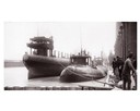
| Date: | 04 1893 |
|---|---|
| Description: | Captain Abe McDougall's whaleback boat, docked at the American Steel Barge Company. |
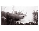
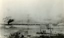
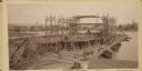
| Date: | 04 1893 |
|---|---|
| Description: | Launching Captain Abe McDougall's whaleback boat, "Christopher Columbus", from the American Steel Barge Company dock. |
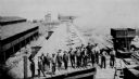
| Date: | 09 19 1892 |
|---|---|
| Description: | Captain Alexander McDougall's whaleback passenger steamer "Christopher Columbus" under construction in the shipyard of the American Steel Barge Company in ... |

| Date: | 1883 |
|---|---|
| Description: | Bird's-eye map of Superior, county seat of Douglas County, on the shores of Lake Superior, with insets of points of interest. |

| Date: | 1890 |
|---|---|
| Description: | Bird's-eye map of West Superior and Superior, with insets of Wright Farm and First Building in Superior. |

| Date: | 1885 |
|---|---|
| Description: | Illustrated view of Superior, as well as Omaha, Kansas City, St. Paul, and Winnipeg. Caption reads: "Superior - The Last Possible Great Marine City in the ... |
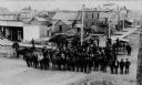
| Date: | 1889 |
|---|---|
| Description: | View of Superior, with a large group of men posting in a road in the foreground, and various buildings behind them. |
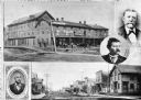
| Date: | 1885 |
|---|---|
| Description: | Collage of images featuring a view of the Nicollet House, a view down a main street, and portrait photographs of O.K. Hall, James Kane, and August Zachau. |
| Date: | 1890 |
|---|---|
| Description: | Elevated view of the coke ovens at the Lehigh Coal and Iron Company. A group of men are posing in the foreground. |
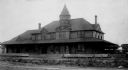
| Date: | 1891 |
|---|---|
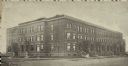
| Description: | Exterior view of the West Superior Hotel. There are pedestrians, a street car, and people riding in horse-drawn carriages on the street in front of the hot... |
| Date: | 1890 |
|---|---|
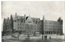
| Description: | Exterior view from across street of Roosevelt Terrace apartments. |

| Date: | 1889 |
|---|---|
| Description: | This 1889 map of Douglas County, Wisconsin, shows the township and range grid, towns, sections, cities and villages, roads, existing and proposed railroads... |

| Date: | 1892 |
|---|---|
| Description: | This 1892 map of Douglas County, Wisconsin, shows the township and range grid, towns, sections, cities and villages, roads, railroads, trails, lakes and st... |

| Date: | 1899 |
|---|---|
| Description: | This 1899 map of Douglas County, Wisconsin, shows the township and range grid, towns, sections, cities, villages and railroad stations, mines, roads, railr... |

| Date: | 1890 |
|---|---|
| Description: | This map of Douglas County, Wisconsin, published around the beginning of the 20th century shows the copper bearing formations in the county on a map that a... |

| Date: | 1800 |
|---|---|
| Description: | This pen and ink drawing with watercolor shows the course of the Black River from Rock Creek, near Greenwood in Clark County, Wisconsin, to its confluence ... |

| Date: | 1896 |
|---|---|
| Description: | This 1896 map of Douglas County, Wisconsin, shows the township and range grid, the towns of Superior, Brule, Gordon, and Nebagamain, sections, cities and v... |

| Date: | 1890 |
|---|---|
| Description: | This map of Superior shows labeled streets, railroads, docks, city wards, and the state line. Relief is shown by hachures. Below the title reads: "Bedford ... |
If you didn't find the material you searched for, our Library Reference Staff can help.
Call our reference desk at 608-264-6535 or email us at: