 Filter: Categories of Wisconsin Historical Images
Filter: County of Douglas
Filter: Subject of church buildings
Filter: Categories of Wisconsin Historical Images
Filter: County of Douglas
Filter: Subject of church buildings

| Date: | 1883 |
|---|---|
| Description: | Bird's-eye map of Superior, county seat of Douglas County, on the shores of Lake Superior, with insets of points of interest. |
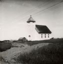
| Date: | 07 1947 |
|---|---|
| Description: | Exterior view of Suomi Synod Church. A farm is visible in the distance. |

| Date: | |
|---|---|
| Description: | Interior view looking toward the altar. Caption reads: "Chapel of St. Joseph Orphan Home, Superior, Wis." |
| Date: | |
|---|---|
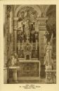
| Description: | Side altar in the chapel at St. Joseph Orphan Home. A large angel statue is on the right and a statue of the Virgin Mary is central. |

| Date: | 1914 |
|---|---|
| Description: | This 1914 map of Douglas County, Wisconsin, shows the township and range grid, towns, sections, cities and villages, roads, railroads, Indian trails, schoo... |

| Date: | 01 1856 |
|---|---|
| Description: | This map shows lots, lots appropriated for churches and schools, streets, parks, court house, and land to be appropriated for railroad depots. An inset map... |
If you didn't find the material you searched for, our Library Reference Staff can help.
Call our reference desk at 608-264-6535 or email us at: