 Filter: Categories of Wisconsin Historical Images
Filter: County of Door
Filter: Subject of service industries
Filter: Subject of bays
Filter: Categories of Wisconsin Historical Images
Filter: County of Door
Filter: Subject of service industries
Filter: Subject of bays

| Date: | 1954 |
|---|---|
| Description: | View looking west from Eagle Bluff toward Nicolet Bay, the Strawberry Islands, and Chambers Island. Three people are sitting on the stone wall of the overl... |

| Date: | 1944 |
|---|---|
| Description: | Shows roads, railroads, schools, dairy plants, seaplane bases, wayside parks, and commercial/municipal fields. "Marathon Forms Map Service, Wisconsin repre... |

| Date: | 1966 |
|---|---|
| Description: | A colored map depiction of Door County, Wisconsin, with pictorial highlights, titled: "Door County — Wisconsin's Air Conditioned Peninsula Playground." |
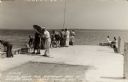
| Date: | 1940 |
|---|---|
| Description: | Photographic postcard view looking out at people standing, and some fishing, on the Northport pier at Death's Door, with the bay in the background. |

| Date: | 1960 |
|---|---|
| Description: | This map shows public boat ramps, parks, highways, beaches, bluffs, Green Bay, Garrett Bay, Europe Bay and Lake, Rowley's Bay and Ellison Bay. The map incl... |
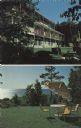
| Date: | |
|---|---|
| Description: | Two views of Egg Harbor Lodge — with the view of the lodge, and of Green Bay. |
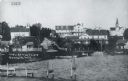
| Date: | 1915 |
|---|---|
| Description: | View of Ephraim from the bay, with a pier in the foreground. Churches are on the left and right, and the Hillside Hotel is in the center near the shore. Ca... |

| Date: | |
|---|---|
| Description: | View of Ephraim from Eagle Bay. Caption reads: "Ephraim, Door County." Text on reverse reads: "Ephraim is a charming town on Door County's western shorelin... |
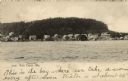
| Date: | 1907 |
|---|---|
| Description: | View of Fish Creek from the bay, with the main dock in the center, and the White Gull Inn on the right. Caption reads: "Fish Creek, Wis." |
If you didn't find the material you searched for, our Library Reference Staff can help.
Call our reference desk at 608-264-6535 or email us at: