 Filter: Categories of Wisconsin Historical Images
Filter: County of Door
Filter: Subject of parks
Filter: Categories of Wisconsin Historical Images
Filter: County of Door
Filter: Subject of parks
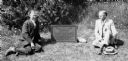
| Date: | 1929 |
|---|---|
| Description: | Richmond Memorial Park Marker with John Donald and Professor Aust seated on either side of it. The marker is located in Gibralter Rock, Wisconsin. It reads... |

| Date: | 08 22 1964 |
|---|---|
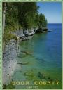
| Description: | A grove of cedar trees on Schoolhouse Beach. Lake Michigan is visible through the trees and a picnic table is placed near the shoreline. |

| Date: | 1944 |
|---|---|
| Description: | Shows roads, railroads, schools, dairy plants, seaplane bases, wayside parks, and commercial/municipal fields. "Marathon Forms Map Service, Wisconsin repre... |

| Date: | 1930 |
|---|---|
| Description: | "Issued by Door County Chamber of Commerce." Shows federal system highways, state highways, county trunk highways, country roads, and parks. Includes direc... |
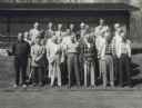
| Date: | 05 19 1957 |
|---|---|
| Description: | Group portrait of men standing on a lawn in front of a building. C.L. (Neal) Harrington is in the third row on the right end. The meeting was held in Penin... |

| Date: | 1960 |
|---|---|
| Description: | View across water towards a man, woman, and two children standing on the rock ledge at Cave Point. Lake Michigan is on the right. |
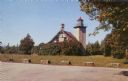
| Date: | 1957 |
|---|---|
| Description: | Color photographic postcard view of the Eagle Lighthouse in Peninsula State Park. |

| Date: | 1962 |
|---|---|
| Description: | Color photograph of a range light built in 1870 to guide ships into the harbor at The Ridges Sanctuary, north of Bailey's Harbor, Door County. The Ridges S... |
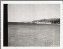
| Date: | 04 17 1963 |
|---|---|
| Description: | Egg Harbor pier. The shoreline and trees are on the right. There is a cottage area along the shoreline along with a small beach. |

| Date: | 1960 |
|---|---|
| Description: | This map shows public boat ramps, parks, highways, beaches, bluffs, Green Bay, Garrett Bay, Europe Bay and Lake, Rowley's Bay and Ellison Bay. The map incl... |

| Date: | 1970 |
|---|---|
| Description: | This map shows roads, parks, swimming beaches, golf courses, yacht harbors, light houses, airports, public hunting grounds, waysides, schools, and fishing ... |

| Date: | 1936 |
|---|---|
| Description: | This map shows campsites, trails, auto roads, surrounding townships, and points of interest, by including pictorial illustrations. Includes an inserted map... |
| Date: | |
|---|---|
| Description: | View from top of cliff looking at Cave Point along the shoreline of Lake Michigan. The text on the reverse reads: "Cave Point. This popular tourist spot is... |

| Date: | |
|---|---|
| Description: | A young boy wearing a camera around his neck is feeding a doe from his hands. |
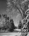
| Date: | 1952 |
|---|---|
| Description: | Winter view of a lake shore road in Peninsula State park. Fresh snow covers the road and trees. |
If you didn't find the material you searched for, our Library Reference Staff can help.
Call our reference desk at 608-264-6535 or email us at: