 Filter: Categories of Wisconsin Historical Images
Filter: County of Door
Filter: Subject of land
Filter: Categories of Wisconsin Historical Images
Filter: County of Door
Filter: Subject of land

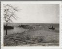
| Date: | 1940 |
|---|---|
| Description: | Color enhanced postcard view of fisherman's shacks on the outlet of Logan's creek on the shore of Lake Michigan. |
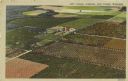
| Date: | 1940 |
|---|---|
| Description: | Color enhanced aerial postcard view of cherry orchards in Door County. |

| Date: | 06 25 1901 |
|---|---|
| Description: | This map shows beacons, buoys, docks, quarries, streets, and buildings. The map inset shows the Harbor of refuge at entrance to Sturgeon Bay and Lake Michi... |

| Date: | 12 28 1908 |
|---|---|
| Description: | This map shows beacons, buildings, streets, and quarries. Two inset maps include: Vicinity of Sturgeon Bay, Wis. and the Harbor of refuge at entrance to St... |
| Date: | 04 16 1963 |
|---|---|
| Description: | Chaudoir Dock in Brussels. The shoreline is on the left and has rocks along its edge. In the background is Lake Michigan. |
| Date: | 04 17 1963 |
|---|---|
| Description: | Egg Harbor pier. The shoreline and trees are on the right. There is a cottage area along the shoreline along with a small beach. |

| Date: | 01 06 1958 |
|---|---|
| Description: | Ahnapee & Western Railway Bridge construction. View is from Highway Bridge. There are ships on the right side beyond the bridge. The forested shoreline cur... |

| Date: | 01 06 1958 |
|---|---|
| Description: | Ahnapee & Western Railway Bridge from north side of frozen Sturgeon Bay. The bridge is made of wood (and steel supports???). There is a dock in the foregro... |

| Date: | |
|---|---|
| Description: | Aerial view of harbors and bridge. Farm fields are on either side of the bridge. The city of Sturgeon Bay is in the distance. There are docks along the sho... |

| Date: | 1900 |
|---|---|
| Description: | This blue line print map shows land use, cables, U.S.L.S.S. walk and clearing, and front and rear range lights on the Porte des Morts Passage. Tree types a... |

| Date: | 1959 |
|---|---|
| Description: | This map includes directories, illustrations, and an inset location map and also covers Rock, Hog, Detroit and Plum islands. |

| Date: | 1936 |
|---|---|
| Description: | This map shows campsites, trails, auto roads, surrounding townships, and points of interest, by including pictorial illustrations. Includes an inserted map... |
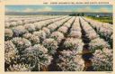
| Date: | |
|---|---|
| Description: | Hand-colored postcard of a cherry orchard with rows of blossoming trees. |

| Date: | |
|---|---|
| Description: | View along shoreline towards Washington Harbor Bluff. There are two men standing at the shoreline on the right. |
| Date: | |
|---|---|
| Description: | View from shoreline towards a boat docked at a pier at Death's Door, with Plum Island in the distance. |
| Date: | |
|---|---|
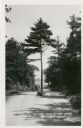
| Description: | View down a road, with a tree growing in the center. Lake Michigan and Plum Island are in the distance. |
| Date: | |
|---|---|
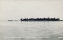
| Description: | View across water towards Little Strawberry Island in Green Bay. The beach on the left side of the island is sandy, and a house can be seen among the trees... |
| Date: | |
|---|---|
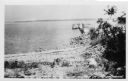
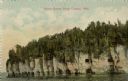
| Description: | Black and white photographic postcard view across water towards Door Bluff on the shore of Lake Michigan. |
| Date: | |
|---|---|
| Description: | View across water towards the bluffs at the northern end of Door County. |
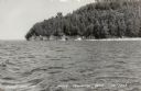
| Date: | 1957 |
|---|---|
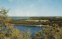
| Description: | Elevated view of Little Sister Bay and the surrounding landscape. |
If you didn't find the material you searched for, our Library Reference Staff can help.
Call our reference desk at 608-264-6535 or email us at: