 Filter: Categories of Wisconsin Historical Images
Filter: County of Door
Filter: Subject of intellectual life
Filter: Categories of Wisconsin Historical Images
Filter: County of Door
Filter: Subject of intellectual life
| Date: | |
|---|---|
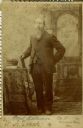
| Description: | Full-length cabinet card portrait in front of a painted backdrop of Carl Nielson [as written on published Roster of Wisconsin Volunteers, Volume 1 and on t... |
| Date: | |
|---|---|
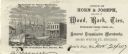
| Description: | Letterhead of the Horn's Pier (Door County) office of Horn & Joseph, dealers in general merchandise, including "Wood, Bark, Ties, Telegraph Poles, Posts, &... |

| Date: | |
|---|---|
| Description: | Letterhead of Reynolds Brothers of Sturgeon Bay, Wisconsin, growers and packers of fresh, frozen, and canned Door County cherries, with a leafy branch lade... |

| Date: | 1930 |
|---|---|
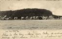
| Description: | Aerial view, looking northeast, across Mud Lake with North Bay in the background, showing cultivated fields and wooded land. |

| Date: | 1930 |
|---|---|
| Description: | Aerial view looking north across the wooded peninsula separating Europe Bay (top) from Newport Bay. This area is now part of Newport State Park. |

| Date: | 1930 |
|---|---|
| Description: | Aerial view of the northern tip of the Door Peninsula, looking north. Europe Lake is in the center, with Europe Bay to the right. Plum Island and Washingto... |

| Date: | 1930 |
|---|---|
| Description: | Aerial view looking northeast, with Rowley's Bay in the foreground. Europe Lake is to the left, with Europe Bay and Newport Bay separated by a narrow peni... |

| Date: | 1930 |
|---|---|
| Description: | Aerial view over northern Door County, looking northeast across Europe Lake and Europe Bay toward Plum and Washington Islands. Farm fields and orchards con... |

| Date: | 1930 |
|---|---|
| Description: | Aerial view from over Moonlight Bay, looking east across Bues Point to Spike Horn Bay and Cana Island. The Cana Island Lighthouse is seen as a ship passes ... |

| Date: | 1930 |
|---|---|
| Description: | Aerial view, looking north, across the beach and pier on Europe Bay to Europe Lake and beyond to Washington Island. The land south (to the right) of Europe... |

| Date: | 1972 |
|---|---|
| Description: | Aerial view of commercial buildings and dwellings along the shore of Lake Michigan. Caption reads: "Baileys Harbor, Wisc." |

| Date: | |
|---|---|
| Description: | Aerial view of Potawatomi State Park, with the Sturgeon Bay shoreline in the background. |

| Date: | 1966 |
|---|---|
| Description: | A colored map depiction of Door County, Wisconsin, with pictorial highlights, titled: "Door County — Wisconsin's Air Conditioned Peninsula Playground." |

| Date: | |
|---|---|
| Description: | Aerial view of harbors and bridge. Farm fields are on either side of the bridge. The city of Sturgeon Bay is in the distance. There are docks along the sho... |

| Date: | 1975 |
|---|---|
| Description: | This map is a reduced reproduction of an annotated map showing location and dates of the operation of Door County post offices. The map includes an article... |
| Date: | |
|---|---|
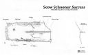
| Description: | Archaeological overhead view site plan of the scow schooner Success. Labels indicate various parts of the ship that remain and how much of the wreck... |

| Date: | |
|---|---|
| Description: | Drawing of a map showing the cruise routes from Eagle Inn Dock and the points of interest. There is a schedule and rates on the reverse. |

| Date: | |
|---|---|
| Description: | Aerial view of Ephraim and Eagle Bay. A two-lane highway runs along the coastline. Caption reads: "Ephraim, Wisconsin." |
| Date: | 1907 |
|---|---|
| Description: | View of Fish Creek from the bay, with the main dock in the center, and the White Gull Inn on the right. Caption reads: "Fish Creek, Wis." |
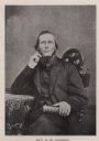
| Date: | 1850 |
|---|---|
| Description: | Portrait of Reverend Andrew M. Iverson of the first Moravian congregation in Door County. |
If you didn't find the material you searched for, our Library Reference Staff can help.
Call our reference desk at 608-264-6535 or email us at: