 Filter: Categories of Wisconsin Historical Images
Filter: County of Door
Filter: Community of Washington
Filter: Categories of Wisconsin Historical Images
Filter: County of Door
Filter: Community of Washington

| Date: | 08 22 1964 |
|---|---|
| Description: | A close-up view of a cedar tree root knuckle, surrounded by grass. This gnarled root was found on Mr. Jack Myers' property on Washington Island. |

| Date: | 08 24 1964 |
|---|---|
| Description: | View of a forest interior as seen from West Harbor Road. A large variety of vegetation grows within the forest. |

| Date: | 08 22 1964 |
|---|---|
| Description: | Two men construct an addition to Mr. Jack Myers' house on Washington Island. |
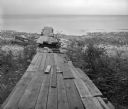
| Date: | 08 20 1964 |
|---|---|
| Description: | View towards horizon of old boat dock extending into Lake Michigan, as seen from the West Harbor of Washington Island. The dock is surrounded by plants and... |
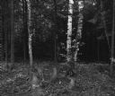
| Date: | 08 20 1964 |
|---|---|
| Description: | View of a dark forest with birch trees and stumps in the foreground. The forest is near the west harbor of Washington Island. |
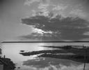
| Date: | 08 19 1964 |
|---|---|
| Description: | View from rocky shoreline of a sun setting through thin clouds over Lake Michigan. A pier juts out over pilings on the right, and a far shoreline is along ... |

| Date: | 08 23 1964 |
|---|---|
| Description: | View from a rocky shoreline of a tree-lined peninsula in the distance. |
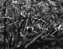
| Date: | 10 18 1964 |
|---|---|
| Description: | Close-up of an apple on an apple tree in the yard of Mrs. Kay Curtis. |

| Date: | 10 18 1964 |
|---|---|
| Description: | View of a side wall and rear entrance of a small country home owned by Mrs. Kay Curtis. A collection of yard tools hang from the siding near a screen door,... |

| Date: | 10 18 1964 |
|---|---|
| Description: | Three outbuildings and a large tree near a country home owned by Mrs. Kay Curtis on Washington Island. |
| Date: | 10 19 1964 |
|---|---|
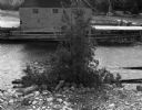
| Description: | Cedar tree on shoreline looking out to an old pier over pilings and rocks. There is a building or boathouse on it. This is a former fishing settlement west... |

| Date: | 1941 |
|---|---|
| Description: | This 1941 tourist map of Washington Island, Wisconsin, shows points of interest and places of business. Some information is shown pictorially. Rock, Hog, D... |

| Date: | 1900 |
|---|---|
| Description: | This blue line print map shows land use, cables, U.S.L.S.S. walk and clearing, and front and rear range lights on the Porte des Morts Passage. Tree types a... |

| Date: | 1959 |
|---|---|
| Description: | This map includes directories, illustrations, and an inset location map and also covers Rock, Hog, Detroit and Plum islands. |

| Date: | |
|---|---|
| Description: | View down concrete pier towards people and a docked ferry, the "C.G. Richter," waiting for the ferry to unload a car. |
| Date: | 07 1951 |
|---|---|
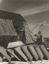
| Description: | A man preparing nets wound on large reels for fishing. A row of tubs are in the foreground and a shed is in the background. |
| Date: | 1940 |
|---|---|
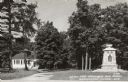
| Description: | Text on front reads: "World War Memorial and School, Washington Island, Wis." The school is on the left and the memorial is on the right, among trees. |
| Date: | 07 09 1974 |
|---|---|
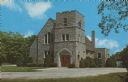
| Description: | Text on reverse reads: "Trinity Lutheran Church, Washington Island, Wisc." A stone church with trees and shrubs. |
If you didn't find the material you searched for, our Library Reference Staff can help.
Call our reference desk at 608-264-6535 or email us at: