 Filter: Categories of Wisconsin Historical Images
Filter: County of Dane
Filter: Year of 1900-1999
Filter: Subject of blueprints
Filter: Categories of Wisconsin Historical Images
Filter: County of Dane
Filter: Year of 1900-1999
Filter: Subject of blueprints

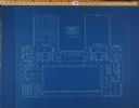
| Date: | 1900 |
|---|---|
| Description: | Floor plan for the second floor library and offices of the State Historical Society building designed by architects Ferry & Clas and constructed in 1900. F... |
| Date: | 1900 |
|---|---|
| Description: | Floor plan for the third floor of the State Historical Society building designed by architects Ferry & Clas and constructed in 1900. |

| Date: | 1900 |
|---|---|
| Description: | Sheet #26 of the plans for the State Historical Society building prepared by architects Ferry & Clas, showing longitudinal sections of corridor 142 and Roo... |

| Date: | 1900 |
|---|---|
| Description: | Sheet # 25 of the plans submitted by architects Ferry & Clas for the construction of the State Historical Society building, showing longitudinal sections o... |
| Date: | 1900 |
|---|---|
| Description: | Sheet #27 of the plans submitted by architects Ferry & Clas for the State Historical Society building showing a section of all four stories of the building... |

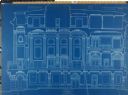
| Date: | 1900 |
|---|---|
| Description: | Sheets 21: Exterior section through the main loggia (Room 226) and portion of the east elevation, 1 1/2 bays of the loggia. |

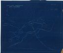
| Date: | 1927 |
|---|---|
| Description: | Blueprint-style map of Frost Woods on the shore of Lake Monona. The map indicates the locations of Indian mounds, an Indian camp, and various plants. There... |

| Date: | 06 08 1960 |
|---|---|
| Description: | Blueprint plat of Sunset Hills sub-division. |

| Date: | 1933 |
|---|---|
| Description: | Blue print and blue line print maps that show local streets, Nakoma Country Club, part of Lake Forest, and part of Lake Wingra. A legend is included that s... |

| Date: | 1933 |
|---|---|
| Description: | This blueprint map shows lakes, roads, railroads, townships and sections. A legend is also included that shows highway surface types. |

| Date: | 1912 |
|---|---|
| Description: | This manuscript blueprint map shows numbered buildings and manuscript annotations. Lake Mendota and streets are labeled. |

| Date: | 1910 |
|---|---|
| Description: | This manuscript blueprint map shows building outlines in vicinity of North Hall and Science Hall, retaining walls, and walkways. |

| Date: | 1907 |
|---|---|
| Description: | This manuscript blueprint map shows land parcels pertaining to University Heights region in Madison, Wisconsin. Streets labeled included, University Avenue... |

| Date: | 1912 |
|---|---|
| Description: | This manuscript blueprint map shows land conditions for future construction development on the University of Wisconsin-Madison campus. It highlights roads ... |

| Date: | 1923 |
|---|---|
| Description: | This manuscript blueprint map shows land parcels regarding the development of the Shorewood community, located on the city side of Lake Mendota. Original c... |
| Date: | 1935 |
|---|---|
| Description: | This manuscript blueprint map shows buildings, water works, a stone wall, and paths. |

| Date: | 1915 |
|---|---|
| Description: | This manuscript blueprint map oriented with north to the upper right. The map includes street names, certifications, and registration. Streets left to righ... |

| Date: | 11 1915 |
|---|---|
| Description: | This manuscript blueprint shows streets and includes certifications and registration. The streets running left to right are: Wenonah Drive, Wanda Place, Na... |

| Date: | 1902 |
|---|---|
| Description: | This blueprint map shows land parcels, parks, blocks, and streets in the region north to Atwood Avenue, south to Lake Monona, west to Evergreen Avenue, and... |

| Date: | 1905 |
|---|---|
| Description: | This blueprint map shows buildings and roads on Bascom Hill. University Avenue, Park street, Charter Street, and Lincoln Drive are labeled. Lake Mendota is... |
If you didn't find the material you searched for, our Library Reference Staff can help.
Call our reference desk at 608-264-6535 or email us at: