 Filter: Categories of Wisconsin Historical Images
Filter: County of Dane
Filter: Subject of wisconsin river (wis.)
Filter: Categories of Wisconsin Historical Images
Filter: County of Dane
Filter: Subject of wisconsin river (wis.)

| Date: | 1861 |
|---|---|
| Description: | Drawn the first year of the Civil War, this colored 1861 map of Dane County shows its towns, cities and lakes. It includes insets of the wards of Madison a... |
| Date: | |
|---|---|
| Description: | That morning is adrift in passing; it cannot last the day. Those years are anchored to each other; there is no other way. |

| Date: | |
|---|---|
| Description: | A house laced straight into the wiry sore of righteousness, squared off and lonely, tingling at the sound of ice, the libertine who drowned. |

| Date: | |
|---|---|
| Description: | View across water towards a bluff along the Wisconsin River. Caption reads: "Phoebie Point on the Wisconsin River, Hillside, Wis." |
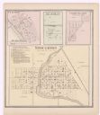
| Date: | 1873 |
|---|---|
| Description: | A page showing four plat maps: Stoughton, Clifton, Deanville, and Cross Plains. |
If you didn't find the material you searched for, our Library Reference Staff can help.
Call our reference desk at 608-264-6535 or email us at: