Visit our other Wisconsin Historical Society websites!
 Filter: Categories of Wisconsin Historical Images
Filter: County of Dane
Filter: Subject of water
Filter: Categories of Wisconsin Historical Images
Filter: County of Dane
Filter: Subject of water
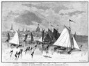
| Date: | 03 09 1878 |
|---|---|
| Description: | Illustration by N.A. Greenback of ice-skaters and iceboats featuring the new Poughkeepsie design of pivoting runners. A key at the bottom of the image iden... |

| Date: | 1879 |
|---|---|
| Description: | Bird's-eye view of Wisconsin State University, now the University of Wisconsin-Madison. Vignettes include Ladies Hall, South Dormitory, University Hall, As... |
| Date: | 1912 |
|---|---|
| Description: | Men harvesting ice at the Conklin Ice House on Lake Mendota. The men are using pike poles to slide the blocks to the conveyor and U-shaped tools to split p... |

| Date: | 1867 |
|---|---|
| Description: | Bird's-eye map of Madison with insets of the University, Rasdall House, Vilas House, and the Wisconsin State Capitol. View includes cattail marsh, smokesta... |

| Date: | 1885 |
|---|---|
| Description: | Bird's-eye map of Madison, State Capital of Wisconsin, County Seat of Dane County, with inset of the Wisconsin State Capitol. |

| Date: | 1852 |
|---|---|
| Description: | Pencil drawing of Madison landscape as seen from University Hill. The main street in the center is State Street, and the building with Greek columns in the... |

| Date: | 1852 |
|---|---|
| Description: | Pencil drawing of view overlooking Madison. The sketch looks down North Hamilton Street from the capitol. Rutted, irregular streets and frame houses mark ... |
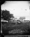
| Date: | 1873 |
|---|---|
| Description: | View from the foot of Carroll Street with the Angle Worm Station at Barnes boat landing on Lake Monona. Shows the Scutt II taken from the first succ... |
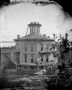
| Date: | 1877 |
|---|---|
| Description: | This building, on an entire block of Spaight and Brearly Streets with Lake Monona, was originally the governor's mansion for Leonard J. Farwell. The Farwel... |
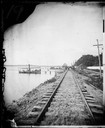
| Date: | 1873 |
|---|---|
| Description: | View down railroad tracks at Angle Worm Station alongside Lake Monona. The station's unusual name originated from a speech given by Captain Frank Barnes ev... |

| Date: | 1836 |
|---|---|
| Description: | The top map is the "Plat of Madison the Capitol of Wisconsin." The bottom map is the "Map of the Four Lake Country. Taken from the Township Maps in the U.S... |
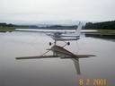
| Date: | 08 02 2001 |
|---|---|
| Description: | A rainy day at Middleton Municipal Airport, formerly the Morey Airfield. |
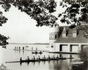
| Date: | |
|---|---|
| Description: | View from shoreline of a crew rowing a Pabst Shell on Lake Mendota near the University of Wisconsin-Madison boathouse, with two men in a canoe and people s... |

| Date: | 1870 |
|---|---|
| Description: | Bird's-eye map of Madison. The Lakeside House resort is in the foreground, which burned in 1877, in what is now Olin Park. |

| Date: | 1875 |
|---|---|
| Description: | Bird's-eye map of Mazomanie. |
| Date: | 01 08 1946 |
|---|---|
| Description: | East Wilson Street scene at the center of South Hancock Street looking South down South Hancock Street across East Wilson Street, taken at site of Reynolds... |
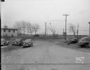
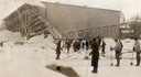
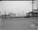
| Date: | 01 08 1946 |
|---|---|
| Description: | South Hancock Street scene looking South down unpaved South Hancock Street at the corner of East Wilson Street, taken at site of Reynolds Bus accident. Bus... |
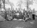
| Date: | 05 26 1945 |
|---|---|
| Description: | Outdoor group portrait of Boy Scouts, Troop #4 from South Side Men's Club, at Four Lakes Council Camporee in Olin Park. |
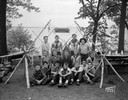
| Date: | 05 26 1945 |
|---|---|
| Description: | Group portrait of Boy Scouts, Troop #24, Explorer Post from Nichols School, at Four Lakes Council Camporee in Olin Park with Lake Monona in the background. |
If you didn't find the material you searched for, our Library Reference Staff can help.
Call our reference desk at 608-264-6535 or email us at:
