Visit our other Wisconsin Historical Society websites!
 Filter: Categories of Wisconsin Historical Images
Filter: County of Dane
Filter: Subject of water
Filter: Categories of Wisconsin Historical Images
Filter: County of Dane
Filter: Subject of water

| Date: | 02 08 1961 |
|---|---|
| Description: | E.H. Lansdowne, 2910 Stevens Street (R), a city fireman at Station No. 4, and Tom Fawcett, 6104 Bridge Road, pilot, stand next to the Madison Police Depart... |
| Date: | 01 13 1961 |
|---|---|
| Description: | Ice boats on lake Monona during the International Skeeter Association regatta. |

| Date: | 01 13 1961 |
|---|---|
| Description: | Two ice-boaters compare notes during the International Skeeter Association regatta on lake Monona. Bill Perrigo (left) talks with Jack Ripp of the host Fou... |

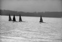
| Date: | 01 13 1961 |
|---|---|
| Description: | Iceboats on Lake Monona at the 18th annual International Skeeter Association regatta. |
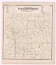
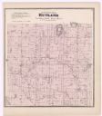
| Date: | 1873 |
|---|---|
| Description: | A plat map of the town of Pleasant Springs. |

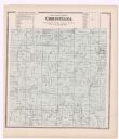
| Date: | 1899 |
|---|---|
| Description: | A plat map of the township of Christiana. |
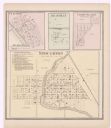
| Date: | 1873 |
|---|---|
| Description: | A page showing four plat maps: Stoughton, Clifton, Deanville, and Cross Plains. |

| Date: | |
|---|---|
| Description: | View from street towards a building that has collapsed. There is a sidewalk in the foreground, and trees surround the building. A body of water is in the b... |
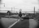
| Date: | |
|---|---|
| Description: | View of a railroad crossing near Lake Monona. Men are on the standing on the road in the background, and other men are working along the railroad tracks. C... |
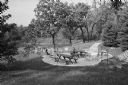
| Date: | 10 04 1960 |
|---|---|
| Description: | A stone terrace overlooking Token creek at the Arthur O. Schroeder home. |

| Date: | 10 04 1960 |
|---|---|
| Description: | Mrs. Arthur O. Schroeder enjoys the view of Token creek with a friend. |
If you didn't find the material you searched for, our Library Reference Staff can help.
Call our reference desk at 608-264-6535 or email us at: