 Filter: Categories of Wisconsin Historical Images
Filter: County of Dane
Filter: Subject of trees
Filter: Subject of maps
Filter: Categories of Wisconsin Historical Images
Filter: County of Dane
Filter: Subject of trees
Filter: Subject of maps
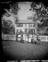
| Date: | 1874 |
|---|---|
| Description: | The Ole Wettlesen family poses in the yard in front of a picket fence with women knitting. Two standing men appear to be examining an unfolded map. The fra... |

| Date: | 01 13 1937 |
|---|---|
| Description: | Sketch map of Township 7 North, Range 9 East, created for the Land Economic Inventory (Bordner Survey). The map shows Picnic Point and the Lake Mendota sho... |
If you didn't find the material you searched for, our Library Reference Staff can help.
Call our reference desk at 608-264-6535 or email us at: