 Filter: Categories of Wisconsin Historical Images
Filter: County of Dane
Filter: Subject of transportation
Filter: Subject of golf
Filter: Categories of Wisconsin Historical Images
Filter: County of Dane
Filter: Subject of transportation
Filter: Subject of golf
| Date: | 05 22 1931 |
|---|---|
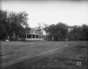
| Description: | The golf course greens and rear view of the Monona Golf Course clubhouse (aka Nathaniel and Harriet Dean House, built 1856) located at 4718 Monona Drive. |

| Date: | 07 26 1930 |
|---|---|
| Description: | Golfers teeing off at at night at the Morgan Driving Course, Mineral Point Road opposite Holly Avenue, Westmorland. |

| Date: | 1920 |
|---|---|
| Description: | Map of the Nakoma neighborhood including the proposed golf grounds. |
| Date: | 05 17 1950 |
|---|---|
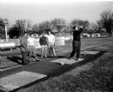
| Description: | Women golfers wait to tee off at the Nakoma Country Club. Left to right: Mae McNearney, Adeline Hendrickson, Erminie Linke, Mrs. C.R. Moe. |
| Date: | 02 27 1957 |
|---|---|
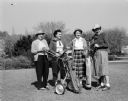
| Description: | Four golfers with stand with their hands in their pockets while watching a fifth golfer, Frank (Moon) Molinaro power off a drive. The other four include, l... |

| Date: | 07 26 1957 |
|---|---|
| Description: | Three women wait to tee off during the second round of the monthly inter-club play at the Blackhawk Country Club. From left are: Katherine Mauer of Maple B... |

| Date: | 08 07 1958 |
|---|---|
| Description: | Three scorers at the annual Women's Interclub golf play between the women golfers of the three Madison private country clubs. Left to right, and the countr... |

| Date: | 1920 |
|---|---|
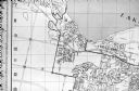
| Description: | This map shows the Nakoma neighborhood in Madison including the "Proposed Golf Ground." The map reads: "Nakoma--the Suburb Superb." The map includes texts ... |

| Date: | 1920 |
|---|---|
| Description: | This map shows a plat of the area, numbered blocks and lots, local streets, roads, parks, Nakoma Country Club golf course, and landscaping. The map is orie... |

| Date: | 1920 |
|---|---|
| Description: | This bird's-eye-view map shows plat of area, numbered blocks and lots, local streets, roads, parks, golf club, schools, buildings, landscaping, and part of... |

| Date: | 1920 |
|---|---|
| Description: | This map, with north oriented to the right, shows a plat of the area, numbered blocks and lots, local streets, roads, parks, a proposed golf course, and la... |

| Date: | 1920 |
|---|---|
| Description: | This hand-colored bird's-eye-view map shows roads, parks, golf club, schools, buildings, landscaping, and part of Lake Wingra. |

| Date: | 06 2014 |
|---|---|
| Description: | View of a golf course, with two bags of golf clubs on wheels and a golf cart parked on a path in the foreground. The course is landscaped with trees, and c... |
| Date: | 06 1960 |
|---|---|
| Description: | Photograph of street map of the Village of Shorewood Hills and Blackhawk Country Club. Lake Mendota is at the top of the map. |

| Date: | 08 06 1960 |
|---|---|
| Description: | Golfers playing the miniature golf course at George Vitense's Golfland; a combination of a miniature course, a par-three 18-hole layout, a driving range an... |
If you didn't find the material you searched for, our Library Reference Staff can help.
Call our reference desk at 608-264-6535 or email us at: