 Filter: Categories of Wisconsin Historical Images
Filter: County of Dane
Filter: Subject of streets
Filter: Subject of bays
Filter: Categories of Wisconsin Historical Images
Filter: County of Dane
Filter: Subject of streets
Filter: Subject of bays

| Date: | 1914 |
|---|---|
| Description: | Includes index of University of Wisconsin buildings, churches, and public buildings. Top of Map reads: '"GET A SQUARE DEAL" AT THE COLLEGE BOOK STORE SHOWN... |
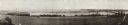
| Date: | 1914 |
|---|---|
| Description: | Panoramic view of Brittingham Bay taken from the north west shore of Brittingham Park. The boathouse is on the left. On the right the railroad tracks cross... |

| Date: | 1960 |
|---|---|
| Description: | Air view focused on the Greenbush neighborhood of Madison prior to its demolition for the Triangle Redevelopment Project. Monona Bay and Brittingham Park a... |

| Date: | |
|---|---|
| Description: | Aerial view of the Greenbush neighborhood in winter partially demolished for the Triangle Redevelopment Project. Monona Bay and Brittingham park are at rig... |

| Date: | 1964 |
|---|---|
| Description: | Aerial view of the Sampson Plaza apartment complex on West Washington Avenue, with Proudfit Street running along the bottom. Neighborhood House can be seen... |

| Date: | 09 26 1957 |
|---|---|
| Description: | Elevated view of the West Tower of the State Office Building at 1 West Wilson Street while it is under construction. Steel vertical and horizontal members,... |
If you didn't find the material you searched for, our Library Reference Staff can help.
Call our reference desk at 608-264-6535 or email us at: