 Filter: Categories of Wisconsin Historical Images
Filter: County of Dane
Filter: Subject of streams
Filter: Subject of formations (geology)
Filter: Categories of Wisconsin Historical Images
Filter: County of Dane
Filter: Subject of streams
Filter: Subject of formations (geology)

| Date: | 1876 |
|---|---|
| Description: | View of a farmstead with fences, haystacks and a wooden outbuilding. Two men are posing on top of McCord Rock, one of them saluting with his hat. Another ... |

| Date: | 1867 |
|---|---|
| Description: | This 1867 manuscript map by Increase Lapham shows the topography and geology of the Blue Mounds region in the Town of Brigham in Iowa County and the towns ... |
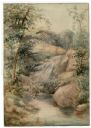
| Date: | |
|---|---|
| Description: | Watercolor painting of a cascade of water over boulders in a stream. Trees and foliage are growing on both sides. The scene may be Madison Creek, west of... |
If you didn't find the material you searched for, our Library Reference Staff can help.
Call our reference desk at 608-264-6535 or email us at: