 Filter: Categories of Wisconsin Historical Images
Filter: County of Dane
Filter: Subject of roads
Filter: Subject of rural areas
Filter: Categories of Wisconsin Historical Images
Filter: County of Dane
Filter: Subject of roads
Filter: Subject of rural areas
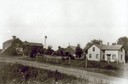
| Date: | 1912 |
|---|---|
| Description: | Exterior of the Droster farm located on Felland Road. The house was built in 1854. |

| Date: | |
|---|---|
| Description: | View from hill over church and cemetery towards fields and town in a valley. |
| Date: | |
|---|---|
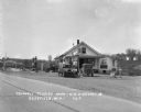
| Description: | Exterior of a gas station/restaurant and the entrance to the Triangle Tourist Park. |
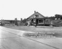
| Date: | 1929 |
|---|---|
| Description: | Exterior view from road of gas station and "dine and dance" restaurant on Highway US-18/US-12, outside the Triangle Tourist Park. The establishment offers ... |

| Date: | 1925 |
|---|---|
| Description: | Elevated view of Mount Vernon from the a grassy hill. |

| Date: | 1911 |
|---|---|
| Description: | View across dirt road of the asylum and grounds. A large three-story building is spread out over several acres. Stairs are leading up to entrances on the s... |

| Date: | |
|---|---|
| Description: | Elevated view of Lake Marion, and the railroad tracks that run along it on the left. A train belching smoke is coming up the tracks. A road runs along the ... |

| Date: | 1927 |
|---|---|
| Description: | This Blue line print map shows trade area boundaries, lakes, farm homes, railways, high schools, public highways, and townships. A symbol key is included i... |

| Date: | 10 18 1978 |
|---|---|
| Description: | View down Old Sauk Pass towards a house in a valley during a rainstorm in rural Wisconsin. |
| Date: | 1979 |
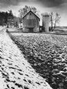
|---|---|
| Description: | A barn and silo, on a snow covered farm along Highway 78, between Mt. Horeb and Black Earth. The farmhouse is behind the barn. A barbed wire fence lines th... |
If you didn't find the material you searched for, our Library Reference Staff can help.
Call our reference desk at 608-264-6535 or email us at:
