 Filter: Categories of Wisconsin Historical Images
Filter: County of Dane
Filter: Subject of roads
Filter: Subject of rivers
Filter: Categories of Wisconsin Historical Images
Filter: County of Dane
Filter: Subject of roads
Filter: Subject of rivers
| Date: | 1908 |
|---|---|
| Description: | The Yahara River from Williamson Street with Lake Monona in the background. House & Barn pictured is located at 601 Riverside Drive. |

| Date: | 1873 |
|---|---|
| Description: | Map of the township of Windsor, from the "Atlas of Dane County." |

| Date: | 1876 |
|---|---|
| Description: | Bird's-eye view of Black Earth. |

| Date: | 1910 |
|---|---|
| Description: | Map of Dane County rural delivery in Madison and the town of Westport. |

| Date: | 1832 |
|---|---|
| Description: | Hand-drawn map in two parts of the route of Governor J.D. Doty. Probably made by Doty in 1832 as a result of his travels with Alexander J. Center. |

| Date: | 1875 |
|---|---|
| Description: | Bird's-eye map of Mazomanie. |

| Date: | 1956 |
|---|---|
| Description: | Aerial view looking northeast from a point over the east end of Middleton, showing the west end of Lake Mendota (right mid-ground). Fox Bluff juts into the... |

| Date: | 1911 |
|---|---|
| Description: | Plat Map of Blooming Grove in "Atlas of Dane County, Wisconsin." |

| Date: | 11 1928 |
|---|---|
| Description: | Aerial view of Stoughton, including the central business district, residential areas, the Yahara River, and the surrounding countryside. |

| Date: | 1855 |
|---|---|
| Description: | Map of the city of Madison, Dane County, published by George Harrison, surveyed and drawn by P. McCabe, and engraved by J.H. Colton & Co., New York. In add... |
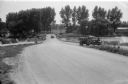
| Date: | 08 07 1945 |
|---|---|
| Description: | State Highway 113 bridge over the Yahara River in Westport. The photograph is taken from the south end of the bridge showing the highway going straight ahe... |
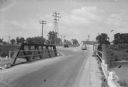
| Date: | 08 07 1945 |
|---|---|
| Description: | State Highway 113 bridge over the Yahara River in Westport. The photograph is taken from the north end of the bridge showing the "blind" curve on the immed... |
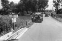
| Date: | 08 07 1945 |
|---|---|
| Description: | State Highway 113 bridge over the Yahara River in Westport, with two automobiles and road signs that read: "County Highway M, Middleton 7 miles"; "State Hi... |
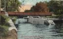
| Date: | 1910 |
|---|---|
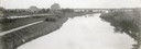
| Description: | View of the Sherman Bridge and Lock and surrounding area on the Yahara River. Caption reads: "Sherman Avenue Bridge and Locks, Yahara River, Madison, Wis." |
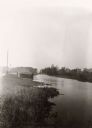
| Date: | 1897 |
|---|---|
| Description: | View along shoreline of the Yahara River, a small building along the shoreline near a road on the left. The Malt House is in the far background, prior to t... |
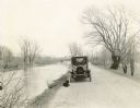
| Date: | 1918 |
|---|---|
| Description: | The Richard Lloyd Jones family dog lies in front of the car parked along the Yahara River Parkway in Tenney Park. Four family members sit in the car. Ther... |
If you didn't find the material you searched for, our Library Reference Staff can help.
Call our reference desk at 608-264-6535 or email us at:


