 Filter: Categories of Wisconsin Historical Images
Filter: County of Dane
Filter: Subject of roads
Filter: Subject of postal service
Filter: Categories of Wisconsin Historical Images
Filter: County of Dane
Filter: Subject of roads
Filter: Subject of postal service

| Date: | 1910 |
|---|---|
| Description: | Map of Dane County rural delivery in Madison and the town of Westport. |

| Date: | 1915 |
|---|---|
| Description: | Wisconsin Avenue looking toward the northwest from the top of the Capitol. The elevated perspective provides an unusual view of the old City Hall (left) an... |

| Date: | 06 1946 |
|---|---|
| Description: | View of the 3500 block of University Avenue, site of the Coca-Cola Bottling plant. There are trees along the road and names on mailboxes of "Middleton" and... |

| Date: | 04 1929 |
|---|---|
| Description: | Newly opened U.S. Post Office on Monona Avenue. There are several automobiles parked on the street outside of the building. |

| Date: | |
|---|---|
| Description: | Newly built U.S. Post Office on Monona Avenue. |

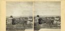
| Date: | 1890 |
|---|---|
| Description: | A view looking down Wisconsin Avenue as seen from the Wisconsin State Capitol grounds. On the right, the post office is visible. |

| Date: | 1918 |
|---|---|
| Description: | Wisconsin State Capitol from Wisconsin Avenue, with the United States Federal Courthouse and Post Office on the left, and Madison City Hall and Christ Pres... |

| Date: | 07 31 1960 |
|---|---|
| Description: | View of a tree and mailbox, with a farmhouse behind below road level along a rural highway. There is a hill in the background with trees. |
| Date: | |
|---|---|
| Description: | Elevated view up Wisconsin Avenue showing City Hall with the Post Office to the right. Also visible is the Presbyterian Church. |

| Date: | |
|---|---|
| Description: | View down an unpaved road with shops on either side. A horse and carriage is coming down the street, and another horse and carriage is parked in front of a... |

| Date: | 1854 |
|---|---|
| Description: | This mid-19th century map of Dane County, Wisconsin, shows the township and range grid, towns, sections, cities, villages and post offices, lakes and strea... |

| Date: | |
|---|---|
| Description: | A vintage view and a modern view of buildings in downtown Blue Mounds, presented as a pair. The buildings house businesses such as restaurants, bars, and a... |

| Date: | 03 2014 |
|---|---|
| Description: | Close-up of a life-sized tin man sculpture with a hatchet attached to his side holding two mailboxes at the side of Highway 78. Snow is covering the ground... |
If you didn't find the material you searched for, our Library Reference Staff can help.
Call our reference desk at 608-264-6535 or email us at: