 Filter: Categories of Wisconsin Historical Images
Filter: County of Dane
Filter: Subject of roads
Filter: Subject of landscape
Filter: Categories of Wisconsin Historical Images
Filter: County of Dane
Filter: Subject of roads
Filter: Subject of landscape

| Date: | 1873 |
|---|---|
| Description: | Main Street, with its dirt, ruts, cows (and presumably manure), but wide enough for easy hitching of wagons and teams. |

| Date: | 12 01 1962 |
|---|---|
| Description: | A farm road between fields in late sunlight, looking towards Mounds Creek in the vicinity of CTH F. |
| Date: | 10 03 1960 |
|---|---|
| Description: | Early morning at a railroad crossing on County Highway A, with houses and a barn in the distance. |

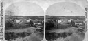
| Date: | 1879 |
|---|---|
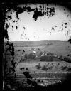
| Description: | Bird's-eye view of Wisconsin State University, now the University of Wisconsin-Madison. Vignettes include Ladies Hall, South Dormitory, University Hall, As... |

| Date: | 1852 |
|---|---|
| Description: | Pencil drawing of Madison landscape as seen from University Hill. The main street in the center is State Street, and the building with Greek columns in the... |

| Date: | 1852 |
|---|---|
| Description: | Pencil drawing of view overlooking Madison. The sketch looks down North Hamilton Street from the capitol. Rutted, irregular streets and frame houses mark ... |

| Date: | 1875 |
|---|---|
| Description: | Bird's-eye map of Mazomanie. |
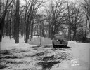
| Date: | 01 19 1945 |
|---|---|
| Description: | Winter scene with automobile parked in front of barricade at west end of Edgewood Drive. |
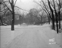
| Date: | 01 19 1945 |
|---|---|
| Description: | Barricades at the east end of Edgewood Drive. |
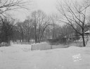
| Date: | 01 19 1945 |
|---|---|
| Description: | Close-up of barricades at the east end of Edgewood Drive. |
| Date: | 11 08 1928 |
|---|---|
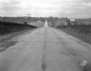
| Description: | Stretch of paved rural highway featuring a proprietary centerline joint, looking towards Mount Horeb from the east. |
| Date: | 11 08 1928 |
|---|---|
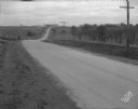
| Description: | Stretch of paved rural highway near Mount Horeb featuring a proprietary centerline joint. |
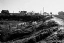
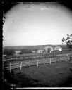
| Date: | 1873 |
|---|---|
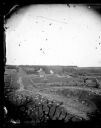
| Description: | View of several farms, including Burton's, Fitlen's and Rustebakke's. Field arrangements and fencing patterns are evident. A man is walking along the bott... |
| Date: | 1873 |
|---|---|
| Description: | View down a rocky rural lane near West Blue Mounds. Zigzag stake and rider split-rail fencing enclose a farmstead, which includes a barn, a frame house, ha... |
| Date: | 1873 |
|---|---|
| Description: | A man is standing in front of a fence along a road in the foreground. Two other men are in the road; one is standing and one is on horseback. Onon Bjorn Da... |
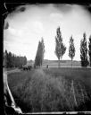
| Date: | |
|---|---|
| Description: | View down a poplar-lined lane with fields and fences on the right. A man and child are sitting in the lane in a horse-drawn wagon with a team of two horses... |
| Date: | 1875 |
|---|---|
| Description: | Elevated view of a man driving a horse-drawn wagon along a rural lane with a man walking in front on the left. In the background is a field, fences, farmho... |
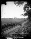
| Date: | 1876 |
|---|---|
| Description: | "One view of the village of Mount Vernon, Wis." a stereograph listed in Dahl's 1877 "Catalogue of Stereoscopic Views." |

| Date: | 05 10 1928 |
|---|---|
| Description: | The Lutheran Church and buildings, seen from Lutheran Church Hill. |
If you didn't find the material you searched for, our Library Reference Staff can help.
Call our reference desk at 608-264-6535 or email us at:
