 Filter: Categories of Wisconsin Historical Images
Filter: County of Dane
Filter: Subject of rivers
Filter: Subject of land
Filter: Categories of Wisconsin Historical Images
Filter: County of Dane
Filter: Subject of rivers
Filter: Subject of land

| Date: | 1873 |
|---|---|
| Description: | Map of the township of Windsor, from the "Atlas of Dane County." |

| Date: | 1861 |
|---|---|
| Description: | Drawn the first year of the Civil War, this colored 1861 map of Dane County shows its towns, cities and lakes. It includes insets of the wards of Madison a... |

| Date: | 1876 |
|---|---|
| Description: | Bird's-eye view of Black Earth. |

| Date: | 1839 |
|---|---|
| Description: | A map of the Wiskonsin [sic] and Neenah or Fox Rivers. |

| Date: | 1836 |
|---|---|
| Description: | The top map is the "Plat of Madison the Capitol of Wisconsin." The bottom map is the "Map of the Four Lake Country. Taken from the Township Maps in the U.S... |

| Date: | 1875 |
|---|---|
| Description: | Bird's-eye map of Mazomanie. |

| Date: | 1956 |
|---|---|
| Description: | Aerial view looking northeast from a point over the east end of Middleton, showing the west end of Lake Mendota (right mid-ground). Fox Bluff juts into the... |

| Date: | 1911 |
|---|---|
| Description: | Plat Map of Blooming Grove in "Atlas of Dane County, Wisconsin." |
| Date: | 1910 |
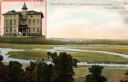
|---|---|
| Description: | View of the outdoor landscape as seen from a window in the Stoughton Hospital, along with an inset of the building in the upper left corner. Caption reads:... |

| Date: | 1948 |
|---|---|
| Description: | Buildings at "Little Norway." From left to right: tool house, Norway house, Haugen homestead. The wagon in foreground is a kubberulle; the wheels are sec... |

| Date: | 1910 |
|---|---|
| Description: | Scale: 1:62500. Topography by Robert Muldrow. Surveyed in 1904. Edition of Aug. 1906, reprinted in 1910. |

| Date: | 1941 |
|---|---|
| Description: | Two rowboats docked in a river surrounded by trees, following a recent snowfall. |

| Date: | 1918 |
|---|---|
| Description: | Elevated view from hill of Yahara River flowing into Lake Kegonsa. |

| Date: | 1918 |
|---|---|
| Description: | Yahara River flowing out of Lake Kegonsa. There appears to be a boat house on the shoreline in the background. |

| Date: | 1918 |
|---|---|
| Description: | Elevated view from hill of the Yahara River flowing south after leaving Lake Kegonsa. Last photo in the album, with the following statement "The little Ya... |
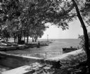
| Date: | 07 22 1949 |
|---|---|
| Description: | Tenney Park breakwater and Lake Mendota. The city of Madison was able to resume construction at no cost. The construction company tearing up East Washingto... |
If you didn't find the material you searched for, our Library Reference Staff can help.
Call our reference desk at 608-264-6535 or email us at:


