 Filter: Categories of Wisconsin Historical Images
Filter: County of Dane
Filter: Subject of real estate development
Filter: Subject of streets
Filter: Categories of Wisconsin Historical Images
Filter: County of Dane
Filter: Subject of real estate development
Filter: Subject of streets

| Date: | 1898 |
|---|---|
| Description: | University Heights from the Chemistry Building on University Avenue. View includes the University of Wisconsin-Madison football field, on the former site o... |
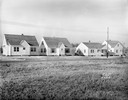
| Date: | 11 23 1938 |
|---|---|
| Description: | A row of houses at 826, 830, 834 & 838 North Fair Oaks Avenue built by the Fitzpatrick Lumber Company in what was the Town of Blooming Grove, now near East... |
| Date: | 08 26 1928 |
|---|---|
| Description: | Front view of the entrance to the North Gardens subdivision, on the corner of North Street and Hoard Street, owned by the Paul E. Stark Company. The stone ... |
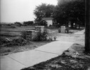
| Date: | 07 26 1928 |
|---|---|
| Description: | Entrance to the North Gardens subdivision on the corner of North Street and Hoard Street, owned by Paul E. Stark Company. |

| Date: | |
|---|---|
| Description: | Poster advertising the Elmside lots for summer homes by Lake Monona. |

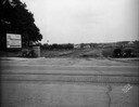
| Date: | 07 15 1957 |
|---|---|
| Description: | Cars park in a new parking lot at the former site of Washington School at 217 North Broom Street. |

| Date: | 01 31 1964 |
|---|---|
| Description: | Aerial view of University Hill Farms area which has grown from a cow pasture to a square-mile housing and business area. 4,000 people live in 750 single-fa... |

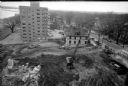
| Date: | 12 16 1964 |
|---|---|
| Description: | View of a crane about to swing a wrecking ball into a building wall at the 30 W. Mifflin Street and Carroll Street corner of the Square as a crowd is looki... |

| Date: | 1902 |
|---|---|
| Description: | This blueprint map shows land parcels, parks, blocks, and streets in the region north to Atwood Avenue, south to Lake Monona, west to Evergreen Avenue, and... |

| Date: | 1910 |
|---|---|
| Description: | This blueprint plat map shows the plan of lots and streets on a Madison hill south of Lake Monona. Includes annotations showing land prices in pencil. |

| Date: | |
|---|---|
| Description: | View across field or vacant lot of grass towards the Stanley Hanks bungalows located at 211-219 Lake Lawn Place off Langdon Street. Hanks probably built th... |

| Date: | 09 30 1953 |
|---|---|
| Description: | Six-unit apartment building at 2902 Harvey Street at Ridge Street, built in 1953. |

| Date: | 04 03 1962 |
|---|---|
| Description: | View looking south from the Shorewood bluff of the Hilldale Shopping Center under construction. Apartments and houses in the Hill Farms neighborhood are in... |
| Date: | 04 08 1957 |
|---|---|
| Description: | Elevated view from the top of central section of the State Office Building at 1 West Wilson Street, showing earth moving equipment at the excavation site f... |

| Date: | 1962 |
|---|---|
| Description: | Aerial view of the Hilldale Shopping Center and environs. Anchor store is Gimbels. N. Midvale Boulevard runs left to right. The State Department of Transpo... |

| Date: | 1967 |
|---|---|
| Description: | Air view looking north toward Lake Mendota. The intersection of West Washington Ave. and S. Park Street is at bottom center. The Triangle Redevelopment Pro... |

| Date: | 03 12 1958 |
|---|---|
| Description: | Joseph Young standing across the street from his nearly-dismantled Young's Restaurant at 622 West Washington Avenue. The restaurant was operated by Young, ... |
If you didn't find the material you searched for, our Library Reference Staff can help.
Call our reference desk at 608-264-6535 or email us at: