Filter: Categories of Wisconsin Historical Images
Filter: County of Dane
Filter: Subject of railroads
Filter: Subject of land
Filter: Categories of Wisconsin Historical Images
Filter: County of Dane
Filter: Subject of railroads
Filter: Subject of land

| Date: | 1873 |
|---|---|
| Description: | Elevated view of several men, some of whom may be railroad workers, posing in front of a Minnesota and St. Paul wood-burning engine at a train crossing. Th... |

| Date: | 1908 |
|---|---|
| Description: | Colored map showing a panoramic view of Madison in great detail. The Wisconsin State Capitol is located at the center, with Lake Mendota in the background ... |

| Date: | 1885 |
|---|---|
| Description: | Bird's-eye map of Madison, State Capital of Wisconsin, County Seat of Dane County, with inset of the Wisconsin State Capitol. |

| Date: | 1875 |
|---|---|
| Description: | Bird's-eye map of Mazomanie. |

| Date: | 1855 |
|---|---|
| Description: | Part of George Harrison's "Map of the City of Madison," showing the development of the isthmus and the small size of the second Capitol (54' x 104') in com... |

| Date: | 1911 |
|---|---|
| Description: | Plat Map of Blooming Grove in "Atlas of Dane County, Wisconsin." |

| Date: | 02 09 1949 |
|---|---|
| Description: | Aerial view of Madison, looking east across the Isthmus including the Wisconsin State Capitol, Lake Mendota, and Lake Monona. |

| Date: | 1873 |
|---|---|
| Description: | Color outline map of Dane County, Wisconsin. |

| Date: | 1890 |
|---|---|
| Description: | A plat map of a portion of Verona in Dane County. |

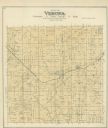
| Date: | 1900 |
|---|---|
| Description: | A hydrographic map of Lake Monona and the adjacent topography. |

| Date: | 1911 |
|---|---|
| Description: | A map of the village of Black Earth and Verona. |

| Date: | 1931 |
|---|---|
| Description: | A map of the village of Verona, Wisconsin. |

| Date: | 1906 |
|---|---|
| Description: | Hand-drawn topographical map of the Turville Estate. |

| Date: | 1892 |
|---|---|
| Description: | Topographical map of Madison and surrounding communities which include Lake Mendota, Lake Monona, Lake Waubesa and Lake Kegonsa. The red dots on the map sh... |

| Date: | 1906 |
|---|---|
| Description: | Topographical map of Turville Point and lands to the South to Nine Springs Creek. |
If you didn't find the material you searched for, our Library Reference Staff can help.
Call our reference desk at 608-264-6535 or email us at: