 Filter: Categories of Wisconsin Historical Images
Filter: County of Dane
Filter: Subject of railroad tracks
Filter: Subject of central business districts
Filter: Categories of Wisconsin Historical Images
Filter: County of Dane
Filter: Subject of railroad tracks
Filter: Subject of central business districts
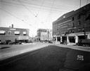
| Date: | 09 17 1931 |
|---|---|
| Description: | View down East Wilson Street from the corner of King Street. The Union Transfer Building is on the right hand side at 155-303 East Wilson Street, Rubin's F... |
| Date: | 09 17 1931 |
|---|---|
| Description: | View across railroad tracks towards the Elver House, later the Wilson Hotel, on East Wilson Street. |
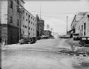
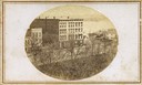
| Date: | 08 12 1931 |
|---|---|
| Description: | Looking north uphill on S. Blount Street toward Williamson Street, across the railroad tracks. The Fauerbach Brewery is on the left, and there is a smokest... |
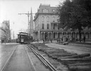
| Date: | 1905 |
|---|---|
| Description: | Construction of new streetcar tracks on the Capitol Square. In the background, on the corner of Main and Carroll streets, is the Park Hotel. Behind the hot... |
| Date: | 1865 |
|---|---|
| Description: | First block of West Main Street. A portion of South Hamilton Street is at the right of the image. The original railroad causeway is at the upper right. |
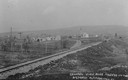
| Date: | 1910 |
|---|---|
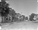
| Description: | Distant view of the town, with railroad tracks in foreground. The church is the highest point in the image. "General View. Blue Mounds in the Distance. Alt... |
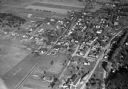
| Date: | 11 1928 |
|---|---|
| Description: | Aerial view of Middleton including businesses, residences, the railroad tracks, and the surrounding countryside. |

| Date: | 1954 |
|---|---|
| Description: | An aerial view of the State Office Building, 1 West Wilson Street. Also shows Olin Terrace, Madison Club and the United States Post Office. |

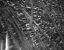
| Date: | 1955 |
|---|---|
| Description: | Aerial view of Schenk's Corners where Atwood Avenue and Winnebago Street cross, looking north west toward East Washington Avenue. ... |
| Date: | 1945 |
|---|---|
| Description: | Aerial view of Schenk's Corners looking east showing the intersection of Atwood Avenue and Winnebago Street. |
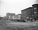
| Date: | 1913 |
|---|---|
| Description: | View from intersection down center of West Main Street. On the corner on the left is a brick bank building. A paint store, a shoe store and other businesse... |
| Date: | 05 1930 |
|---|---|
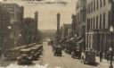
| Description: | View of heavy automobile traffic, delivery trucks and pedestrians on State Street, seen looking west from the 200 block. In the background is Bascom Hill, ... |

| Date: | 1945 |
|---|---|
| Description: | An aerial view, looking northeast, that includes the intersection at Atwood and Fair Oaks Avenues. Elmside Circle Park is on the bottom left. The Madison-K... |

| Date: | |
|---|---|
| Description: | Aerial view of the Isthmus from over Lake Monona. The Wisconsin State Capitol and Lake Mendota are in the background. In the foreground is John Nolen Drive... |
If you didn't find the material you searched for, our Library Reference Staff can help.
Call our reference desk at 608-264-6535 or email us at: