 Filter: Categories of Wisconsin Historical Images
Filter: County of Dane
Filter: Subject of railroad tracks
Filter: Subject of aerial photographs
Filter: Categories of Wisconsin Historical Images
Filter: County of Dane
Filter: Subject of railroad tracks
Filter: Subject of aerial photographs

| Date: | 1908 |
|---|---|
| Description: | A panoramic aerial view of the Isthmus taken from a kite. Lake Mendota is to the right in the background with Picnic Point jutting into the lake. The photo... |
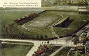
| Date: | 1908 |
|---|---|
| Description: | Aerial view of Camp Randall Stadium on the University of Wisconsin-Madison campus. Top image on Place File card. Caption reads: "Bird's-eye View, Camp Ra... |
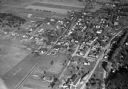
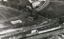
| Date: | 11 1928 |
|---|---|
| Description: | Aerial view of Middleton including businesses, residences, the railroad tracks, and the surrounding countryside. |
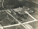
| Date: | 1937 |
|---|---|
| Description: | An aerial view of the Forest Products Laboratory. The view shows a newly completed railroad underpass and street approach. |

| Date: | 1954 |
|---|---|
| Description: | An aerial view of the State Office Building, 1 West Wilson Street. Also shows Olin Terrace, Madison Club and the United States Post Office. |
| Date: | |
|---|---|
| Description: | Aerial view of University Avenue near the Veteran's Administration Hospital. The J.S. Timlin Lumber Company is along University Avenue. |
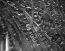
| Date: | |
|---|---|
| Description: | Aerial view of University Avenue near the Veteran's Administration Hospital. At the bottom is the J.S. Timlin Lumber Company. |

| Date: | 1959 |
|---|---|
| Description: | Elevated view looking east from shoreline of Lake Monona towards Monona shoreline. There is a road, railroad tracks, and a rocky beach area with parked au... |

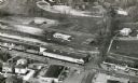
| Date: | 06 27 1949 |
|---|---|
| Description: | Aerial photograph looking west across Walnut Street at Forest Products Laboratory and the construction site of the Veterans Administration Hospital. Railr... |

| Date: | 1955 |
|---|---|
| Description: | Aerial view of Schenk's Corners where Atwood Avenue and Winnebago Street cross, looking north west toward East Washington Avenue. ... |
| Date: | 1945 |
|---|---|
| Description: | Aerial view of Schenk's Corners looking east showing the intersection of Atwood Avenue and Winnebago Street. |

| Date: | 03 28 1959 |
|---|---|
| Description: | Elevated view of a parking lot along John Nolen Drive on the shore of a partially frozen Lake Monona. Railroad tracks are in the foreground on the right. |

| Date: | 1945 |
|---|---|
| Description: | An aerial view, looking northeast, that includes the intersection at Atwood and Fair Oaks Avenues. Elmside Circle Park is on the bottom left. The Madison-K... |

| Date: | |
|---|---|
| Description: | Aerial view of the Isthmus from over Lake Monona. The Wisconsin State Capitol and Lake Mendota are in the background. In the foreground is John Nolen Drive... |
If you didn't find the material you searched for, our Library Reference Staff can help.
Call our reference desk at 608-264-6535 or email us at: