 Filter: Categories of Wisconsin Historical Images
Filter: County of Dane
Filter: Subject of presbyterian churches
Filter: Subject of lakes
Filter: Categories of Wisconsin Historical Images
Filter: County of Dane
Filter: Subject of presbyterian churches
Filter: Subject of lakes
| Date: | |
|---|---|
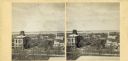
| Description: | Elevated view up Wisconsin Avenue showing City Hall with the Post Office to the right. Also visible is the Presbyterian Church. |

| Date: | 1969 |
|---|---|
| Description: | This map is pen and ink on paper and shows the location of churches, local streets, railroads, parks, Middleton, Shorewood Hills, Monona, Maple Bluff, McFa... |
If you didn't find the material you searched for, our Library Reference Staff can help.
Call our reference desk at 608-264-6535 or email us at: