 Filter: Categories of Wisconsin Historical Images
Filter: County of Dane
Filter: Subject of land use
Filter: Subject of suburbs
Filter: Categories of Wisconsin Historical Images
Filter: County of Dane
Filter: Subject of land use
Filter: Subject of suburbs
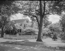
| Date: | 06 08 1935 |
|---|---|
| Description: | J. Frank Kessenich house, 205 Lakewood Boulevard, Lakewood subdivision. |
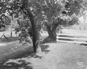
| Date: | 06 16 1949 |
|---|---|
| Description: | Slightly elevated view of the Freda Winterble property, 901 University Bay Drive, with white rope showing where new road will require the cutting down of l... |
| Date: | 06 1972 |
|---|---|
| Description: | View along the 2700 block of Fish Hatchery Road, with billboard advertising residential lots in Tower Hill Park (a development by Llyman McKee and William ... |
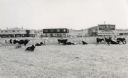
| Date: | 10 08 1945 |
|---|---|
| Description: | A large barn and outbuilding on the Quaker Oats farm, 4202 Monona Drive. |

| Date: | 12 23 1953 |
|---|---|
| Description: | Aerial view of Crawford Heights looking northwest across Nakoma Road. The photograph shows Nakoma Road, the West Beltline, Cherokee School, and Midvale Bou... |

| Date: | 12 23 1953 |
|---|---|
| Description: | Aerial view of Crawford Heights looking north along Midvale Boulevard. The photograph shows Nakoma Road, the West Beltline, Cherokee School, and Midvale Bo... |

| Date: | 12 23 1953 |
|---|---|
| Description: | Aerial view of Crawford Heights looking northeast along Nakoma Road, across the West Beltline. The photograph shows Midvale Boulevard and Lake Mendota appe... |

| Date: | 12 22 1953 |
|---|---|
| Description: | Aerial photograph of Crawford Heights looking west along the West Beltline. The photograph shows Nakoma Road, Midvale Boulevard, Cherokee School, and the A... |

| Date: | 12 23 1953 |
|---|---|
| Description: | Aerial view of Crawford Heights looking west along the West Beltline. The photograph shows Nakoma Road, Midvale Boulevard, Cherokee School, and the Arboret... |

| Date: | 12 23 1953 |
|---|---|
| Description: | Aerial view of Crawford Heights looking north by northwest along the West Beltline with Cherokee School and the Arboretum at lower right and Lake Mendota a... |

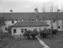
| Date: | 07 03 1954 |
|---|---|
| Description: | View of the flooded yard of Mr. and Mrs. Willard Stormer at 829 Burbank Place in the Garden Homes subdivision of Madison. |

| Date: | 1971 |
|---|---|
| Description: | This map shows streets, highways, railroads, parks, colleges, cemeteries, county clubs, University of Wisconsin, Truax Field, Middleton, Shorewood Hills, M... |

| Date: | 10 08 1945 |
|---|---|
| Description: | A barn on the Quaker Oats farm at 4202 Monona Drive. |

| Date: | 10 08 1945 |
|---|---|
| Description: | A barn on the Quaker Oats farm at 4202 Monona Drive. |

| Date: | 10 08 1945 |
|---|---|
| Description: | A barn on the Quaker Oats farm on 4202 Monona Drive. A sign above the barn door reads: "Branch Warehouse of William Le[?] Warehouses, Public Bonded Warehou... |

| Date: | 10 08 1945 |
|---|---|
| Description: | A barn at the Quaker Oats farm at 4202 Monona Drive. |

| Date: | 10 1911 |
|---|---|
| Description: | This map shows lot numbers, building lines, roads, trees, and Indian mounds. Relief is shown by contours. Includes manuscript annotations marking parks. |

| Date: | 1960 |
|---|---|
| Description: | Aerial view of rural landscape with suburban construction in foreground. Cottage Grove Road is at left with the newly constructed Acewood Boulevard crossin... |

| Date: | 05 22 1954 |
|---|---|
| Description: | Madison housing development at the corner of McKenna Boulevard and Gilbert Road in the Orchard Ridge neighborhood. Shows homes, sprawling backyards and tel... |
If you didn't find the material you searched for, our Library Reference Staff can help.
Call our reference desk at 608-264-6535 or email us at: