 Filter: Categories of Wisconsin Historical Images
Filter: County of Dane
Filter: Subject of lakes
Filter: Subject of school buildings
Filter: Categories of Wisconsin Historical Images
Filter: County of Dane
Filter: Subject of lakes
Filter: Subject of school buildings

| Date: | 1930 |
|---|---|
| Description: | Aerial view of near west side, including West High School, the Forest Products Laboratory, Lake Mendota, and Picnic Point. |

| Date: | 1874 |
|---|---|
| Description: | View of the University of Wisconsin-Madison from the Wisconsin State Capitol. |
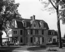
| Date: | 10 08 1947 |
|---|---|
| Description: | Exterior view of Norbertine Novitiate, 4123 Monona Drive. Originally the Frank Allis home built in 1893-94. Lake Monona is in the background. |

| Date: | 02 06 1948 |
|---|---|
| Description: | Looking east along Regent Street with snow on the ground. Visible are Lake Wingra, Monona Bay, railroad causeway across Monona, Lake Mendota, Hoyt Park, We... |

| Date: | 1904 |
|---|---|
| Description: | This 1904 map of Dane County, Wisconsin, shows postal routes, post office locations, towns, sections, cities and villages, roads, railroads, collection box... |

| Date: | 1908 |
|---|---|
| Description: | Panoramic view of Madison taken from Summit Avenue looking East South East toward Lake Monona. Included in the view are the Camp Randall bleachers, St. Rap... |

| Date: | 1955 |
|---|---|
| Description: | Shows city limits, adjoining municipalities, and schools. Indexes, illustrations, ancillary map of Dane County, and ancillary map of Madison business secti... |

| Date: | 1888 |
|---|---|
| Description: | Shows ward divisions and street railways, as well as University of Wisconsin buildings, churches, and schools. Cataloged from copy with right and left edge... |

| Date: | 1925 |
|---|---|
| Description: | This map shows the public schools and their school districts. The bottom of the map reads:" Old buildings and sites in red. New buildings and sites in blac... |

| Date: | 1929 |
|---|---|
| Description: | This is a blue line print map that shows local streets, railroads, local businesses, schools, parks, cemeteries, the airport, the state capitol, the Univer... |

| Date: | 1968 |
|---|---|
| Description: | Aerial view looking southwest, with Lake Mendota at right and East Gorham Street running from the bottom left corner. Lincoln School is in the foreground, ... |

| Date: | 1968 |
|---|---|
| Description: | Air view of the University of Wisconsin-Madison campus looking north to Lake Mendota. Picnic Point, currently part of the Lakeshore Nature Preserve, and Ca... |

| Date: | 1967 |
|---|---|
| Description: | Air view looking north toward Lake Mendota. The intersection of West Washington Ave. and S. Park Street is at bottom center. The Triangle Redevelopment Pro... |
If you didn't find the material you searched for, our Library Reference Staff can help.
Call our reference desk at 608-264-6535 or email us at: