 Filter: Categories of Wisconsin Historical Images
Filter: County of Dane
Filter: Subject of hills
Filter: Subject of shrubs
Filter: Categories of Wisconsin Historical Images
Filter: County of Dane
Filter: Subject of hills
Filter: Subject of shrubs
| Date: | 12 29 1932 |
|---|---|
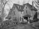
| Description: | View from hill looking down at the Chandler B. and Frances Chapman home exterior from the southeast after the fire. There is a man near the porch entrance. |

| Date: | 04 13 1928 |
|---|---|
| Description: | Charles E. Mendenhall house, 205 N. Prospect Avenue. |

| Date: | 1935 |
|---|---|
| Description: | Exterior view of the Wisconsin State Capitol during a rain shower. |
| Date: | 1924 |
|---|---|
| Description: | Richard T. Ely residence, 205 North Prospect Street. This house is Georgian revival in style and was built by Richard & Anna Ely in 1896. The architect was... |

| Date: | 1939 |
|---|---|
| Description: | The Gilmore-Weiss home, 120 Ely Place (formerly Prospect Avenue), designed by Frank Lloyd Wright. |

| Date: | |
|---|---|
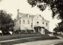
| Description: | View of the University of Wisconsin president's home at 130 North Prospect. |

| Date: | 06 27 1949 |
|---|---|
| Description: | Outdoor portrait of Mrs William L. (Dorothy) Smith, St. Louis, Missouri, and her son Tony, visiting at the home of her parents, Mr. and Mrs. A.J. Opostedal... |

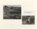
| Date: | |
|---|---|
| Description: | View looking down hill of several buildings. More hills are in the far background. Caption reads: "Blue Mounds at a Distance, Altitude 1760 FT." |

| Date: | 1925 |
|---|---|
| Description: | A view looking up a winding road with rows of utility lines on both sides. The road is partially fenced. |
| Date: | 1929 |
|---|---|
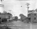
| Description: | View down a commercial street, with an automobile coming down the street. There is a soda/ice cream shop which offers tobacco, cigars, and candy. The City ... |

| Date: | |
|---|---|
| Description: | A path along railroad tracks on the left and a river on the right. Tall bushes are along the river. Trees and a fence are to the left lining the railroad t... |

| Date: | 1960 |
|---|---|
| Description: | Elevated view of landscape, with large dead birch tree, looking south east near the junction of Highways 19 and 78. |

| Date: | 05 23 1961 |
|---|---|
| Description: | Field and hills along Katzenbeuchel Road. There is a fence in the foreground. |

| Date: | |
|---|---|
| Description: | View from shoreline across Lake Mendota towards Maple Bluff. There are pilings in the foreground on the left. |

| Date: | 05 24 1961 |
|---|---|
| Description: | View of small domed hill on Highway 19, surrounded by fields. |
| Date: | 06 25 1964 |
|---|---|
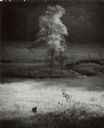
| Description: | Single tree in the valley meadow below Stewart park. A small loop of a stream is to the right of the tree. A wooded hill is in the background. |

| Date: | |
|---|---|
| Description: | You came to know that book by its covered distance, well remembered by the measure of the trudging barefoot mile |
| Date: | |
|---|---|
| Description: | On the map it shows the turkey buzzards circling overhead to tell us who we are and what the odds. Don't count; a promise is no more than just a s... |
If you didn't find the material you searched for, our Library Reference Staff can help.
Call our reference desk at 608-264-6535 or email us at:

