 Filter: Categories of Wisconsin Historical Images
Filter: County of Dane
Filter: Subject of golf
Filter: Subject of streets
Filter: Categories of Wisconsin Historical Images
Filter: County of Dane
Filter: Subject of golf
Filter: Subject of streets

| Date: | 1920 |
|---|---|
| Description: | Map of the Nakoma neighborhood including the proposed golf grounds. |

| Date: | 1920 |
|---|---|
| Description: | This map shows the Nakoma neighborhood in Madison including the "Proposed Golf Ground." The map reads: "Nakoma--the Suburb Superb." The map includes texts ... |

| Date: | 1920 |
|---|---|
| Description: | This map, with north oriented to the right, shows a plat of the area, numbered blocks and lots, local streets, roads, parks, a proposed golf course, and la... |

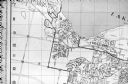
| Date: | 1920 |
|---|---|
| Description: | This hand-colored bird's-eye-view map shows roads, parks, golf club, schools, buildings, landscaping, and part of Lake Wingra. |
| Date: | 06 1960 |
|---|---|
| Description: | Photograph of street map of the Village of Shorewood Hills and Blackhawk Country Club. Lake Mendota is at the top of the map. |
If you didn't find the material you searched for, our Library Reference Staff can help.
Call our reference desk at 608-264-6535 or email us at: