Filter: Categories of Wisconsin Historical Images
Filter: County of Dane
Filter: Subject of fields (agriculture)
Filter: Subject of water
Filter: Categories of Wisconsin Historical Images
Filter: County of Dane
Filter: Subject of fields (agriculture)
Filter: Subject of water
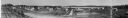
| Date: | 1916 |
|---|---|
| Description: | Panoramic view of the Wingra area from the railroad tracks north of Gregory Street. Looking towards Lake Wingra, across Monroe Street. |

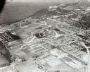
| Date: | 1950 |
|---|---|
| Description: | Aerial view of the Frank Lloyd-Wright-dsigned Unitarian Church under construction and the Veteran's Administration Hospital, also under construction, to th... |
| Date: | 1926 |
|---|---|
| Description: | Elevated view of Picnic Point on Lake Mendota from the University of Wisconsin-Madison Soils building. |
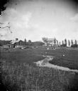
| Date: | |
|---|---|
| Description: | Boys fish in a stream, with cattle, horses, a farmhouse and a barn in the background. |
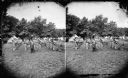
| Date: | 1876 |
|---|---|
| Description: | Quite possibly this is the "View of the Grand Music Band" listed in the "Centennial Views of the City of Madison, July 4th, 1876. Views of Chicago Light Gu... |

| Date: | 1874 |
|---|---|
| Description: | Distant view of the town from a hill with houses, garden plots, businesses and churches. |

| Date: | 1930 |
|---|---|
| Description: | Aerial view above Shorewood Hills near Madison, looking northeast. |

| Date: | 03 24 1913 |
|---|---|
| Description: | Picnic Point from the University Farm fields, now known as Observatory Hill. |

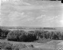
| Date: | 1909 |
|---|---|
| Description: | View from Sunset Point in Owen Park, which is now a part of Hoyt Park. Lake Mendota is in the distance. |

| Date: | 1909 |
|---|---|
| Description: | View from the University of Wisconsin service building smokestack of south Madison, including Mills Street, Mound Street, and the Greenbush. Lake Monona is... |

| Date: | |
|---|---|
| Description: | An aerial view of both Picnic Point and Second Point looking toward the isthmus. Members of the Jackson Family had summer homes at Second Point at this tim... |
| Date: | 09 1958 |
|---|---|
| Description: | Aerial view of University Farms neighborhood near Lake Mendota. |

| Date: | 1900 |
|---|---|
| Description: | Elevated view looking towards Monona Bay, possibly from atop the University of Wisconsin Power Plant smokestack. |

| Date: | 1910 |
|---|---|
| Description: | Aerial view looking toward Lake Wingra. In the foreground is the Yawkey-Crowley Lumber Yard. The company built it's warehouse at 1542 Monroe Street between... |
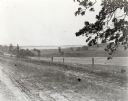
| Date: | |
|---|---|
| Description: | View from the western countryside towards Lake Wingra, looking east. In the foreground is a dirt road and fence. |

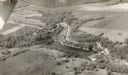
| Date: | 1955 |
|---|---|
| Description: | An aerial view of Middleton. In the foreground is a baseball field, and beyond are houses, woods, fields, and Lake Mendota. |
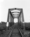
| Date: | 1912 |
|---|---|
| Description: | View across a railroad bridge with metal truss system over the Sugar River. |
If you didn't find the material you searched for, our Library Reference Staff can help.
Call our reference desk at 608-264-6535 or email us at: