 Filter: Categories of Wisconsin Historical Images
Filter: County of Dane
Filter: Subject of farmhouses
Filter: Subject of roads
Filter: Categories of Wisconsin Historical Images
Filter: County of Dane
Filter: Subject of farmhouses
Filter: Subject of roads
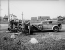
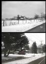
| Date: | 11 13 1933 |
|---|---|
| Description: | Frank Lloyd Wright's 1929 L-29 Cord Phaeton automobile and an overturned Choles Floral Company delivery truck, driven by Frost Choles, at an accident scene... |
| Date: | 03 04 1932 |
|---|---|
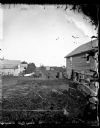
| Description: | Piper Brothers farm scene, 4718 Odana Road near Midvale. |
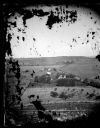
| Date: | 1873 |
|---|---|
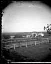
| Description: | View of several farms, including Burton's, Fitlen's and Rustebakke's. Field arrangements and fencing patterns are evident. A man is walking along the bott... |
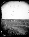
| Date: | 1873 |
|---|---|
| Description: | View down a rocky rural lane near West Blue Mounds. Zigzag stake and rider split-rail fencing enclose a farmstead, which includes a barn, a frame house, ha... |
| Date: | 1873 |
|---|---|
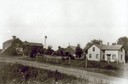
| Description: | A man is standing in front of a fence along a road in the foreground. Two other men are in the road; one is standing and one is on horseback. Onon Bjorn Da... |
| Date: | |
|---|---|
| Description: | View, looking south of a man wearing a hat in a horse-drawn buggy on a rural lane in Mount Horeb. On the right a man and three children are standing near t... |
| Date: | 1912 |
|---|---|
| Description: | Exterior of the Droster farm located on Felland Road. The house was built in 1854. |
| Date: | 07 1967 |
|---|---|
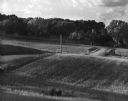
| Description: | A country road and electrical lines run through a field of oats. On the left is a road, and a farmhouse is in the background on a hill. |

| Date: | 1928 |
|---|---|
| Description: | View from grassy hill of uptown Cross Plains. The Catholic Church (St. Francis Xavier) is on the right, and farmhouses and other buildings are among fields... |

| Date: | 06 06 1961 |
|---|---|
| Description: | Brothers Greg, left, and Mark Herrling drive a four-wheel buggy pulled by two ponies down a driveway with the family home visible in the background. This i... |

| Date: | |
|---|---|
| Description: | You came to know that book by its covered distance, well remembered by the measure of the trudging barefoot mile |

| Date: | 1927 |
|---|---|
| Description: | This Blue line print map shows trade area boundaries, lakes, farm homes, railways, high schools, public highways, and townships. A symbol key is included i... |
| Date: | |
|---|---|
| Description: | A vintage view and a modern view of 4718 Odana Road, presented as a pair. The vintage view shows the Piper Brothers Farm. The modern view shows a house wit... |

| Date: | 10 18 1978 |
|---|---|
| Description: | View down Old Sauk Pass towards a house in a valley during a rainstorm in rural Wisconsin. |

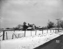
| Date: | 07 23 1960 |
|---|---|
| Description: | View from a bluff looking south. A highway is on the right; one farm building is among a stand of trees at the bottom of the hill. |
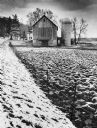
| Date: | 1979 |
|---|---|
| Description: | A barn and silo, on a snow covered farm along Highway 78, between Mt. Horeb and Black Earth. The farmhouse is behind the barn. A barbed wire fence lines th... |
If you didn't find the material you searched for, our Library Reference Staff can help.
Call our reference desk at 608-264-6535 or email us at:
