 Filter: Categories of Wisconsin Historical Images
Filter: County of Dane
Filter: Subject of cities and towns
Filter: Subject of wetlands
Filter: Categories of Wisconsin Historical Images
Filter: County of Dane
Filter: Subject of cities and towns
Filter: Subject of wetlands

| Date: | 1974 |
|---|---|
| Description: | This 1974 map is a reproduction of the original survey maps of the Four Lakes region of Dane County, Wisconsin. It shows sections, lakes, rivers, wetlands,... |

| Date: | 1835 |
|---|---|
| Description: | This manuscript map of Dane County, Wisconsin, from the first half of the 19th century shows the township and range grid, sections, cities and villages bot... |

| Date: | 1835 |
|---|---|
| Description: | These maps of the towns of Westport, Madison, and Blooming Grove, Dane County, Wisconsin, show sections, roads, trails, lakes and streams, and wetlands fro... |
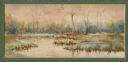
| Date: | 1906 |
|---|---|
| Description: | Watercolor painting of the Yahara River at Lake Monona, with trees in the background and wetlands in the foreground. |
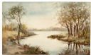
| Date: | 1906 |
|---|---|
| Description: | Watercolor painting of the Yahara River, with large trees on the shoreline. Note: '05 & '06 were the years when Tenney Park and the Yahara River Parkway ... |
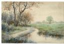
| Date: | |
|---|---|
| Description: | Watercolor painting of the Yahara River north of Lake Mendota. Trees are on the banks to the left with foliage throughout. A meadow is on the right. |
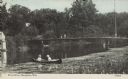
| Date: | 08 25 1911 |
|---|---|
| Description: | Text on front reads: "River Scene, Stoughton, Wis." Two women in a canoe on the Yahara River near wetlands foliage, with two people on the pedestrian bridg... |
If you didn't find the material you searched for, our Library Reference Staff can help.
Call our reference desk at 608-264-6535 or email us at: